Volver atrás

Gota d Agua

Ação direta de cidadania que foi parte do curso Mapeando o Comum Urbano. A ação foi realizada durante a manhã do sábado 26 de Outubro nas “Piscinas Naturais de Corais da Praia do Seixas”, que situa-se no litoral sul e fica em frente à “Falésia do Cabo Branco” e ao Farol do Cabo Branco e à Estação Cabo Branco – Ciência, Cultura e Artes.

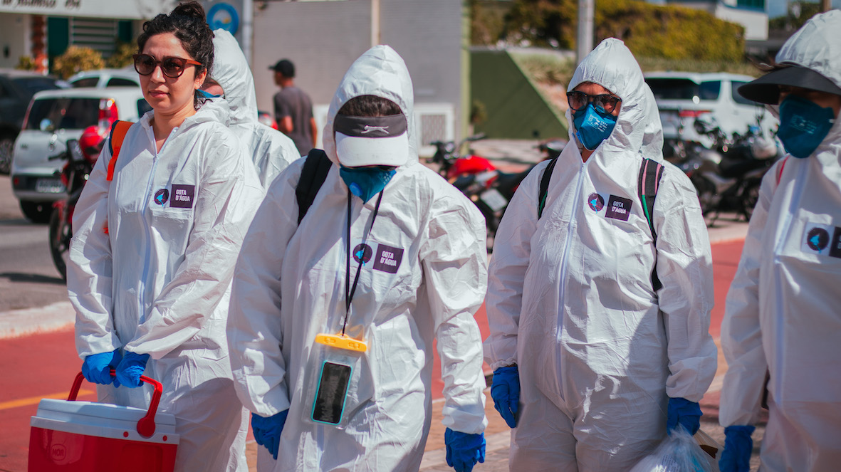
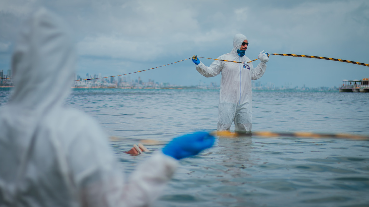
A ação consistiu em uma simulação e performance ativa em que professores, estudantes e extensionistas vestiram-se de cientistas e pesquisadores que embarcaram em um catamarã turístico em total silêncio e com roupas específicas de proteção contra poluição e resíduos tóxicos. Outros estavam vestidos como seguranças e trajavam roupas pretas. Todo o percurso de barco foi marcado pela curiosidade dos turistas e pessoas em torno dos trajes e do grupo que destoava do sentido costumeiro de lazer. Os matérias utilizados além das roupas de proteção, foram fitas de isolamento de área nas cores amarelo e preta, luvas óculos, macacões e um megafone.

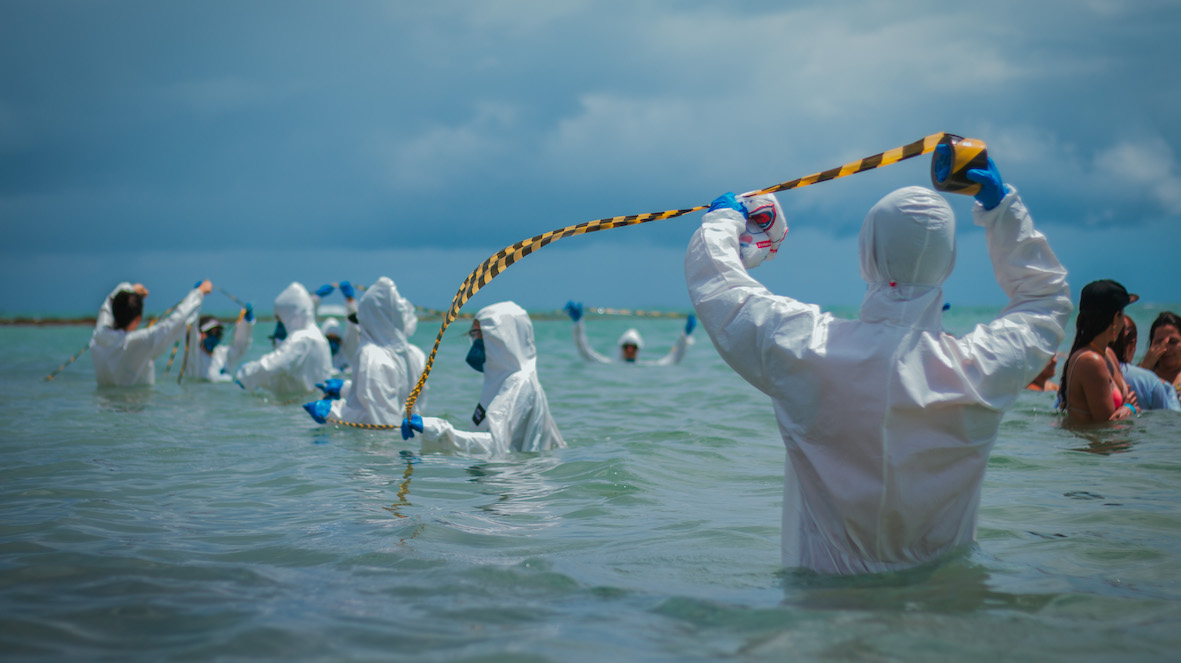
Ao ancorar o barco a tripulação de cientistas e seguranças desceram e seguiram em fila indiana e para isolar uma área de corais, em seguida foi feita um fala no megafone de alerta aos perigos e danos que vem acontecendo tanto aos corais e à falésia e a mata atlântica devido ao turismo predatório e às atuais e antigas políticas estimuladas, desenvolvidas ou ausentes no e pelo Estado em suas diversas esferas: Federal, Estadual e Municipal. Muitos turistas se interessaram em perguntar o porquê da ação, e o capitão da embarcação divulgou no microfone que a ação estava sendo desenvolvida por estudantes e professores preocupados com as condições ambientais já citadas. Divulgou-se a conta do Instagram do projeto e a plataforma digital.

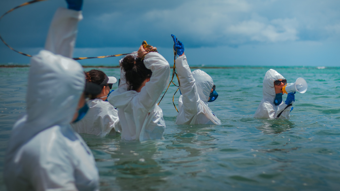
Em seguida o grupo se dirigiu para a outra parte dos corais e novamente cercou uma determinada área. Teve-se acesso ao microfone da embarcação e pode-se divulgar qual era a intenção da ação, os riscos que o “bem comum” da cidade vem tendo, assim como todo o intuito de alerta radical e de ação educativa e criativa. Após isso houve a interação da equipe com os turistas e trabalhadores que se mostraram em parte interessados na causa. O projeto e suas plataformas digitais tiveram um alcance inesperado de mensagens. Ao retornar para a praia o grupo ainda se reuniu para um almoço e discutiu as futuras ações a serem realizadas dentro da mesma proposta teórica e metodológica da cartografia radical e crítica e da discussão sobre os bens comuns ameaçados na capital paraibana.

A equipe muito comprometida e multidisciplinar continua ativa e considera a ação como exitosa. A mobilidade urbana, a segregação sócio-espacial, a poluição e o desmatamento, assim como a verticalização da cidade são elementos que fazem parte dessa problematização sobre as cidades e seus bens comuns.

* Texto por Ricardo Bruno Cunha Campos (Cientista Social – Professor da SEECT – PB)

Volver atrás

A second life for European Union’s pavillion

Water 4 Bits, a Second Life for Expo92 Europe Pavillion, was a synchronize (and visitable) installation in both physical and digital space that explored dreams, nightmares and the realities of post-modern technology at the heart of Seville’s Technology Park.

The physical space was the European Pavilion at the Cartuja Technology Park, Seville. The park is the result of the urban recycling of the site of the World Fair held in the city in 1992. Although it is a successful, productive environment, some of the world fair pavilions still stand empty. One such is the European Pavillion, which nowadays looks like a ruin from a novel by J G Ballard: subterranean, empty, partly flooded. The installation in question aims to turn it into a type of visitor’s center for the archaeological exploration of the future.

Europe pavillion

The digital space was a 3D clone of the physical space created in a synthetic or Metaverse world, Open Simulator, which could be described as a free and distributed version of Second Life. This digital space shows environmental data collected from the pavilion in real-time by means of sensors (arduino-squidbee / light, relative humidity, temperature) while simultaneously displaying a project to transform the pavilion into an experimental citizen’s media lab, on the lines of the Prado and Hangar media labs (Madrid and Barcelona).

open simulator

Meanwhile, the process was documented at the Centro Andaluz de Arte Contemporáneo by means of two screens that act like mirrors: one shows the physical space and project details, while the other is an Open Simulator version of the pavilion in the future, which can be toured by visitors.

Installation

The project raised public awareness about the place as a space of opportunity for Seville and explores its future use as an experimental citizen’s media lab. Digital artists, architects, students and the public were invited to take part in a forum on the participatory construction of the project.

Volver atrás

Situation Room

The term Situation Room is normally used to designate a secret place used in times of crisis to assess and monitor data for decision making purposes. Its origins can be traced back to World War II with the invention of computers, digitalization, and the collaboration of architects and the military. These rooms are equipped with monitors and data boards used to control everything from flows crossing the strait of Gibraltar to nuclear fission processes in Nuclear Power plants and the life support mechanisms on board the International Space Station.

Go to book: http://www.dpr-barcelona.com/index.php?/projects/situation-room/

Volver atrás

Technological Observatory of the Straits

Many meetings and workshops organised led to a process of discussion and experimentation that eventually produced the idea of the Technological Observatory of the Straits. Some of the main issues that intersect with the transformations now in process, as discussed above, are beginning to overlap and cross each other, and so common hypotheses are being raised in different collective spaces for theoretical discussion and practice. It is difficult to name and locate all the spaces and times that have shaped the steps of this nomadic path. Conferences, workshops, meetings in person or through chat, celebrations, conversations in different contexts, mobilisations, compilations of material shared on the tiki-wiki, online publications and comments, telephones. Collective paths and also individual paths that converge in Fadaiat and the Observatory, and that we can synthesise for the purposes of this text, without forgetting that the experiences go much further than the text. For us, all these moments of intersection have affective dimensions and intensities that cannot be reversed.

Volver atrás

The Zone

The Zone is a project by Román Torre and Pablo DeSoto. It is the winning project in the 6th DKV – Álvarez Margaride Production Scholarship, organised by LABoral Art Center in conjunction with the DKV insurance company, and it was produced during a residency at Plataforma 0, LABoral’s production centre. It was exhibited from June 20 to October 21, 2018

The Zone is an interactive installation that presents, in a didactic way, some elements of the exclusion zone of Fukushima in Japan. It reflects  about the Anthropocene/Capitalocene landscapes of our damaged planet. It takes its name from a real physical space, the exclusion zone established as a consequence of the Fukushima nuclear disaster in Japan.

The exclusion zone is the evacuated area as a result of the maximum level nuclear accident unleashed when the earthquake and the tsunami forces of March 11, 2011, collided with The Fukushima Daiichi nuclear power plant. 160.000 people were forced to leave their homes and workplaces in a matter of minutes when the containment buildings which contain four reactors, began to explode one after another, spreading their invisible radioactive particles into the environment. The area declared uninhabitable for humans comprises a geographical area of 800 square kilometres around the destroyed nuclear power station.

The Zone is also a metaphor that constructs the mythology of the present, warning us against dreams of technological progress turned into nightmares. The project explores the possibilities of art & cartography displays in understanding contemporary environmental disasters.

The Zone. Photo by Marcos Morilla, courtesy of LABoral.

The project consists of four main parts: 1/ an outdoors installation, 2/ an interactive map, 3/ a workers area, 4/ a documentation area.

An outdoors installation occupy the public space at the entrance of LABoral Art Center. It consists of a deposit of radioactive bags evoking the storage facilities for contaminated soil from the nuclear crisis spread over all the ridges of Fukushima prefecture.

The main piece is an 80 square metres interactive map. The map is projected on the floor allowing the visitors to walk on the top of it. Five digitally fabricated objects on its surface, when approached by the visitor, activate a specific story. These stories include 1/ the earthquake and tsunami, 2/ the multiple nuclear reactor meltdowns, 3/ the evacuation of the population, 4/ the first journalist to get into the Exclusion Zone, and 5/ the citizen science as a response to the radiological disaster.

The workers’ area is a tribute to the thousands of workers, mostly subcontract ones, who enter Fukushima Daiichi Nuclear Power Plant everyday or work in the decontamination brigades. It includes a Geiger Counter developed by Safecast, a citizen science community established in Japan as a response to the nuclear disaster.

The documentation area includes books, reports, photos and academic papers on the Fukushima Daiichi nuclear disaster. It additionally includes resources from primary sources collected in Japan between November 2011 and February 2012. Selected Academic Papers are organised into six main categories: Social Movements, Citizen Science, Philosophy, Ecosystems, Activism, Workers and Public Health.

Volver atrás

WikiPlaza

WikiPlaza was an experimental, long-term project that brought together several collectives of architects, hackers and activists. The idea sprung up of generating a hybrid public space in which to experiment with information and communication technologies as tools for individual and communal emancipation, based on free software and hardware, web 2.0 tools and an open and transparent use of spaces and systems.

Beginning with a generic discussion of new freedoms in the global metropolis —mobility, flexibility, cyborg transformations, ecology and participation — WikiPlaza Paris project consisted of a series of diagrams that proposed turning the place de la Bastille into a citizenship laboratory in the framework of the network society. Concepts and tools drawn from digital networks —especially from the communities of free software— were applied to the social construction of an open and participative public space that would favor use by its inhabitants. The concepts developed therein recombine ideas and practices most of which are already present on the web. The idea is that, in the construction of a permanent institutional space, we can attempt to bring into play the creative and organizational experiences of social movements over the last decade, including indymedia, hackmeetings, Wikipedia, Fadaiat and Mayday, as well as the more commercial ones from the so-called web 2.0, including Google, Blogger, Flickr, Myspace, Facebook and Youtube, to name but a few of the most outstanding. Continually redrawn from the first stages of work, the conceptual diagrams we seek to apply in the wikiplaza are as follows.

Wikiplaza Paris was set up as part of the Festival Future en Seine. Festival de la Ville Numerique, organised by Paris Cap Digital and curated by Ewen Chardonnet. It operated from 29 May to 7 June, 2009. The project was a co-production between the Cap Digital team, hackitectura.net and the Labomedia, directed by Sergio Moreno from hackitectura.net and Laura Hernández Andrade. It involved a production team of approximately 30 people.
The WikiPlaza has located in Place de la Bastille, one of the emblematic sites in the French capital, and functioned as the main hub of the festival. The architecture was developed by Straddle3 and Hackitectura, and consisted of a geodesic dome with a 15 meter diameter and a height of 7.5 meters, offering a covered area of some 180 square meters. To complement it, we designed a demountable platform based on the Layher system but adapted to the geometry of the prototype, which had to include an access ramp, a bicycle parking area, a ‘quarterpipe’ for skaters and stepped seating, all designed to enhance its integration with the everyday use of the public square. This base also allowed us to counterweigh the structure given that there was an express ban on drilling into the paving in the square. This was done using a sophisticated system of cabling and counterweights beneath the platform. The base and dome were complemented by the Mille Plateaux furniture element designed and digitally fabricated.