Volver atrás

Critical Cartography of the Straits of Gibraltar

Hackitectura’s map Cartografía Crítica del Estrecho (Cartography of the Straits of Gibraltar) creates an alternative understanding of the Spanish-Moroccan border region. The border is not an abstract geopolitical line but an increasingly complicated, contested space. The inversely oriented (north at the bottom) map highlights connections between southern Spain and northern Morocco to show a single region. A multitude of migrants enters Europe in flows, past motion sensors, semi-military repression and expulsion. The idea of the map is to follow the flows that already traverse the border, such as migrants, Internet data and cell phone calls, as well as capital and police. The flows reshape the very border into a border region. In this mapping project, Hackitectura and their collaborators map the border region to contest and transcend it.

cara a
Volver atrás

Fadaiat: freedom of movement, freedom of knowledge

The straits of gibraltar is a mirror-territory of the transformations taking place in the world today: globalisation, migrations, borders, citizenship, network-society, communication, technologies… the border is a crossed-place, an extensive territory of life and mobile confinements where multiple social practices put pressure on established limits. new spaces and relationships emerge from and through the border between southern europe and northern africa.

the book and all it entails plays an important and irreplaceable role, but it is just a fragment of a process that goes far beyond it in terms of both time and subject matter. Here it opens new possible becomings that were mere conjectures until it was written; it is a line with relative autonomy running parallel to the other relatively autonomous part-projects and establishing fruitful exchanges among them, which in turn become an opportunity for new projects.

through this process, and specially the publishing of this book, we want to contribute to the existence of new spaces of social and technological hybridisations that, by forging new paths, continually (re)invent world(s).

Volver atrás

From Cairo to Gaza

A documentary road movie that runs the 330km that separate Cairo from the southern border of Gaza during the days of Operation Cast Lead in January 2009, which caused more than 1,400 deaths and thousands of wounded among the Palestinian population. The trips follow the attempts of Egyptian civil society to break the blockade imposed by their own government by organizing actions and protests to show their solidarity.

Road movie documental que recorre los 330km que separan El Cairo de la frontera sur de Gaza durante los días de la Operación Plomo Fundido en enero de 2009, que causó más de 1400 muertos y miles de heridos entre la población palestina. Los viajes siguen los intentos de la sociedad civil egipcia de quebrar el bloqueo impuesto por su propio gobierno organizando acciones y protestas para mostrar su solidaridad.
 

vimeo https://vimeo.com/11807140 w=1280&h=960

TITLE: De El Cairo a Gaza
INTERNATIONAL TITLE: From Cairo to Gaza
LENGHT: 13 min
FORMAT: video PAL 16/9
LANGUAGE: english / arabic
SUBTITLES: spanish
COUNTRY-DATE OF PRODUCTION: Egypt-Spain / december 2010

Volver atrás

Gaza cartography

Este trabajo recoge un catálogo de mapas, software y vídeos coordinados de forma narrativa usando tecnologías avanzadas de descripción del espacio (GIS, Software, Modelado 3D) mostrando aspectos que no serían evidentes en una primera lectura. Pueden ser extrapolados a territorios y contextos de paz sujetos a tensiones y transformaciones en que la arquitectura y el urbanismo tengan una importancia relevante.

See atlas https://issuu.com/filoatlas/docs/cartografiando_gaza

Cartografiando Gaza es una prolongación del Taller de Invierno de 2009 del Área de Proyectos Arquitectónicos en la Escuela Politécnica Superior de la Universidad de Alicante y que en la presente edición contó con el comisariado de Régine Debatty, José Pérez de Lama y Pablo de Soto, y la coordinación del catedrático José María Torres Nadal y los profesores Miguel Mesa del Castillo y Juan Carlos Castro.

Volver atrás

Mapping the Commons

A research project and an open urban laboratory to explore that complex concept called the urban commons. The project proposes a method where the commons are discussed, defined with parameters and, sometimes, represented in short videos.

Go to site: http://mappingthecommons.net

Volver atrás

Situation Room

The term Situation Room is normally used to designate a secret place used in times of crisis to assess and monitor data for decision making purposes. Its origins can be traced back to World War II with the invention of computers, digitalization, and the collaboration of architects and the military. These rooms are equipped with monitors and data boards used to control everything from flows crossing the strait of Gibraltar to nuclear fission processes in Nuclear Power plants and the life support mechanisms on board the International Space Station.

Go to book: http://www.dpr-barcelona.com/index.php?/projects/situation-room/

Volver atrás

The Global Street

The Global Street is an online video-cartography linking the streets and squares the streets and squares across Tunis, Cairo, Madrid, New York, Tokyo, Istanbul, São Paulo, Belo Horizonte and Rio de Janeiro.

From the Arab revolutions to the 15M movement in Spain, from Occupy Wall Street in the USA to the Hydrangea revolt in Japan, from #direngezi in Turkey to the June Journeys in Brazil, music has played an essential role to sustain and in some ways synchronize protestors hearts, political agendas and imaginations.

The Global Street assembles a selection of affective songs and disruptive beats which were part of already historical atmospheres of democratic change: from the chanting crowds in Tahrir Square and Puerta del Sol to the Taksim Gezi Park barricade drums, from the Gospel band in Zuccotti Park to the Brazilian protest funk.

Go to site.

Volver atrás

The Zone

The Zone is a project by Román Torre and Pablo DeSoto. It is the winning project in the 6th DKV – Álvarez Margaride Production Scholarship, organised by LABoral Art Center in conjunction with the DKV insurance company, and it was produced during a residency at Plataforma 0, LABoral’s production centre. It was exhibited from June 20 to October 21, 2018

The Zone is an interactive installation that presents, in a didactic way, some elements of the exclusion zone of Fukushima in Japan. It reflects  about the Anthropocene/Capitalocene landscapes of our damaged planet. It takes its name from a real physical space, the exclusion zone established as a consequence of the Fukushima nuclear disaster in Japan.

The exclusion zone is the evacuated area as a result of the maximum level nuclear accident unleashed when the earthquake and the tsunami forces of March 11, 2011, collided with The Fukushima Daiichi nuclear power plant. 160.000 people were forced to leave their homes and workplaces in a matter of minutes when the containment buildings which contain four reactors, began to explode one after another, spreading their invisible radioactive particles into the environment. The area declared uninhabitable for humans comprises a geographical area of 800 square kilometres around the destroyed nuclear power station.

The Zone is also a metaphor that constructs the mythology of the present, warning us against dreams of technological progress turned into nightmares. The project explores the possibilities of art & cartography displays in understanding contemporary environmental disasters.

The Zone. Photo by Marcos Morilla, courtesy of LABoral.

The project consists of four main parts: 1/ an outdoors installation, 2/ an interactive map, 3/ a workers area, 4/ a documentation area.

An outdoors installation occupy the public space at the entrance of LABoral Art Center. It consists of a deposit of radioactive bags evoking the storage facilities for contaminated soil from the nuclear crisis spread over all the ridges of Fukushima prefecture.

The main piece is an 80 square metres interactive map. The map is projected on the floor allowing the visitors to walk on the top of it. Five digitally fabricated objects on its surface, when approached by the visitor, activate a specific story. These stories include 1/ the earthquake and tsunami, 2/ the multiple nuclear reactor meltdowns, 3/ the evacuation of the population, 4/ the first journalist to get into the Exclusion Zone, and 5/ the citizen science as a response to the radiological disaster.

The workers’ area is a tribute to the thousands of workers, mostly subcontract ones, who enter Fukushima Daiichi Nuclear Power Plant everyday or work in the decontamination brigades. It includes a Geiger Counter developed by Safecast, a citizen science community established in Japan as a response to the nuclear disaster.

The documentation area includes books, reports, photos and academic papers on the Fukushima Daiichi nuclear disaster. It additionally includes resources from primary sources collected in Japan between November 2011 and February 2012. Selected Academic Papers are organised into six main categories: Social Movements, Citizen Science, Philosophy, Ecosystems, Activism, Workers and Public Health.

Volver atrás

WikiPlaza

WikiPlaza was an experimental, long-term project that brought together several collectives of architects, hackers and activists. The idea sprung up of generating a hybrid public space in which to experiment with information and communication technologies as tools for individual and communal emancipation, based on free software and hardware, web 2.0 tools and an open and transparent use of spaces and systems.

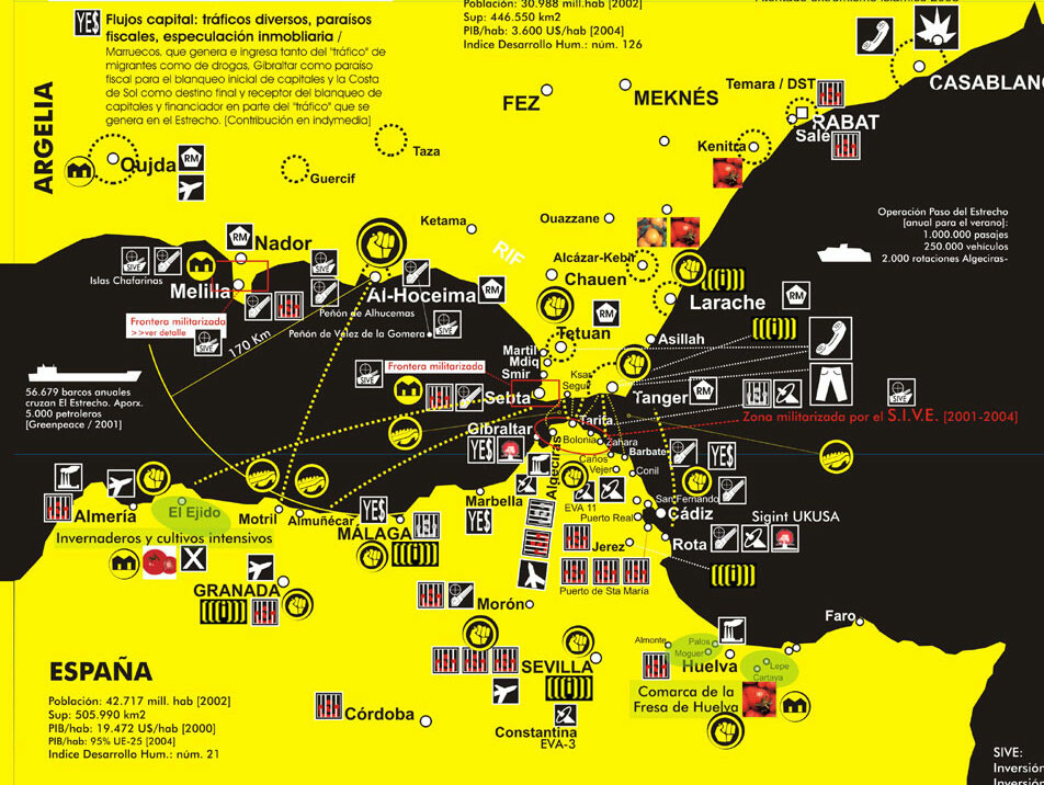
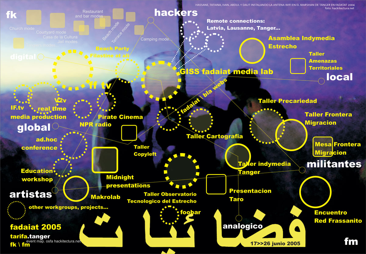
Beginning with a generic discussion of new freedoms in the global metropolis —mobility, flexibility, cyborg transformations, ecology and participation — WikiPlaza Paris project consisted of a series of diagrams that proposed turning the place de la Bastille into a citizenship laboratory in the framework of the network society. Concepts and tools drawn from digital networks —especially from the communities of free software— were applied to the social construction of an open and participative public space that would favor use by its inhabitants. The concepts developed therein recombine ideas and practices most of which are already present on the web. The idea is that, in the construction of a permanent institutional space, we can attempt to bring into play the creative and organizational experiences of social movements over the last decade, including indymedia, hackmeetings, Wikipedia, Fadaiat and Mayday, as well as the more commercial ones from the so-called web 2.0, including Google, Blogger, Flickr, Myspace, Facebook and Youtube, to name but a few of the most outstanding. Continually redrawn from the first stages of work, the conceptual diagrams we seek to apply in the wikiplaza are as follows.

Wikiplaza Paris was set up as part of the Festival Future en Seine. Festival de la Ville Numerique, organised by Paris Cap Digital and curated by Ewen Chardonnet. It operated from 29 May to 7 June, 2009. The project was a co-production between the Cap Digital team, hackitectura.net and the Labomedia, directed by Sergio Moreno from hackitectura.net and Laura Hernández Andrade. It involved a production team of approximately 30 people.
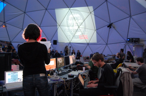
The WikiPlaza has located in Place de la Bastille, one of the emblematic sites in the French capital, and functioned as the main hub of the festival. The architecture was developed by Straddle3 and Hackitectura, and consisted of a geodesic dome with a 15 meter diameter and a height of 7.5 meters, offering a covered area of some 180 square meters. To complement it, we designed a demountable platform based on the Layher system but adapted to the geometry of the prototype, which had to include an access ramp, a bicycle parking area, a ‘quarterpipe’ for skaters and stepped seating, all designed to enhance its integration with the everyday use of the public square. This base also allowed us to counterweigh the structure given that there was an express ban on drilling into the paving in the square. This was done using a sophisticated system of cabling and counterweights beneath the platform. The base and dome were complemented by the Mille Plateaux furniture element designed and digitally fabricated.