Volver atrás

A second life for European Union’s pavillion

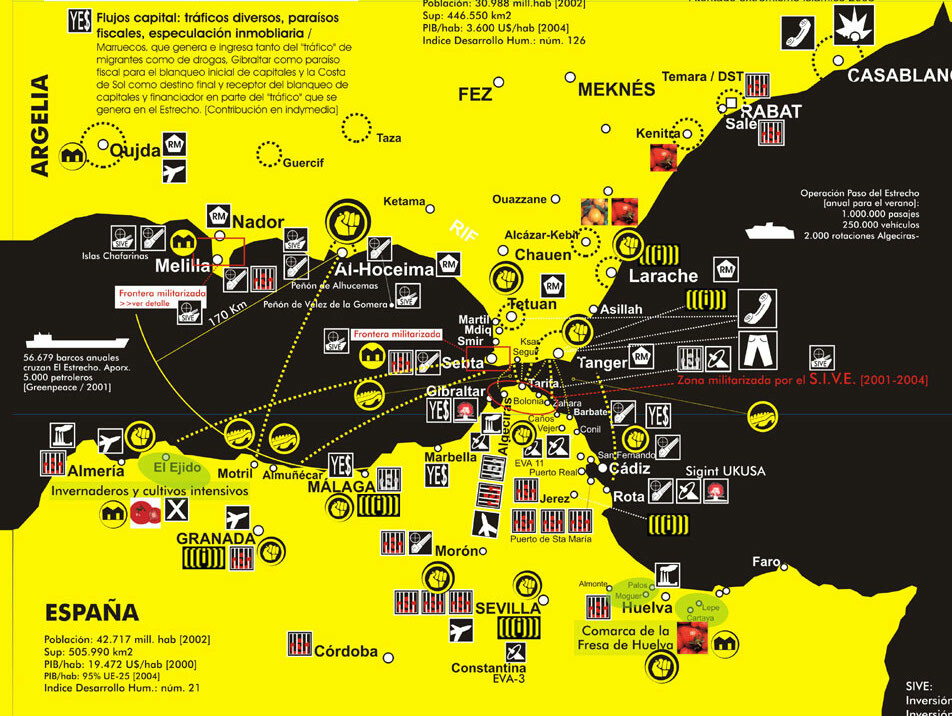
Water 4 Bits, a Second Life for Expo92 Europe Pavillion, was a synchronize (and visitable) installation in both physical and digital space that explored dreams, nightmares and the realities of post-modern technology at the heart of Seville’s Technology Park.

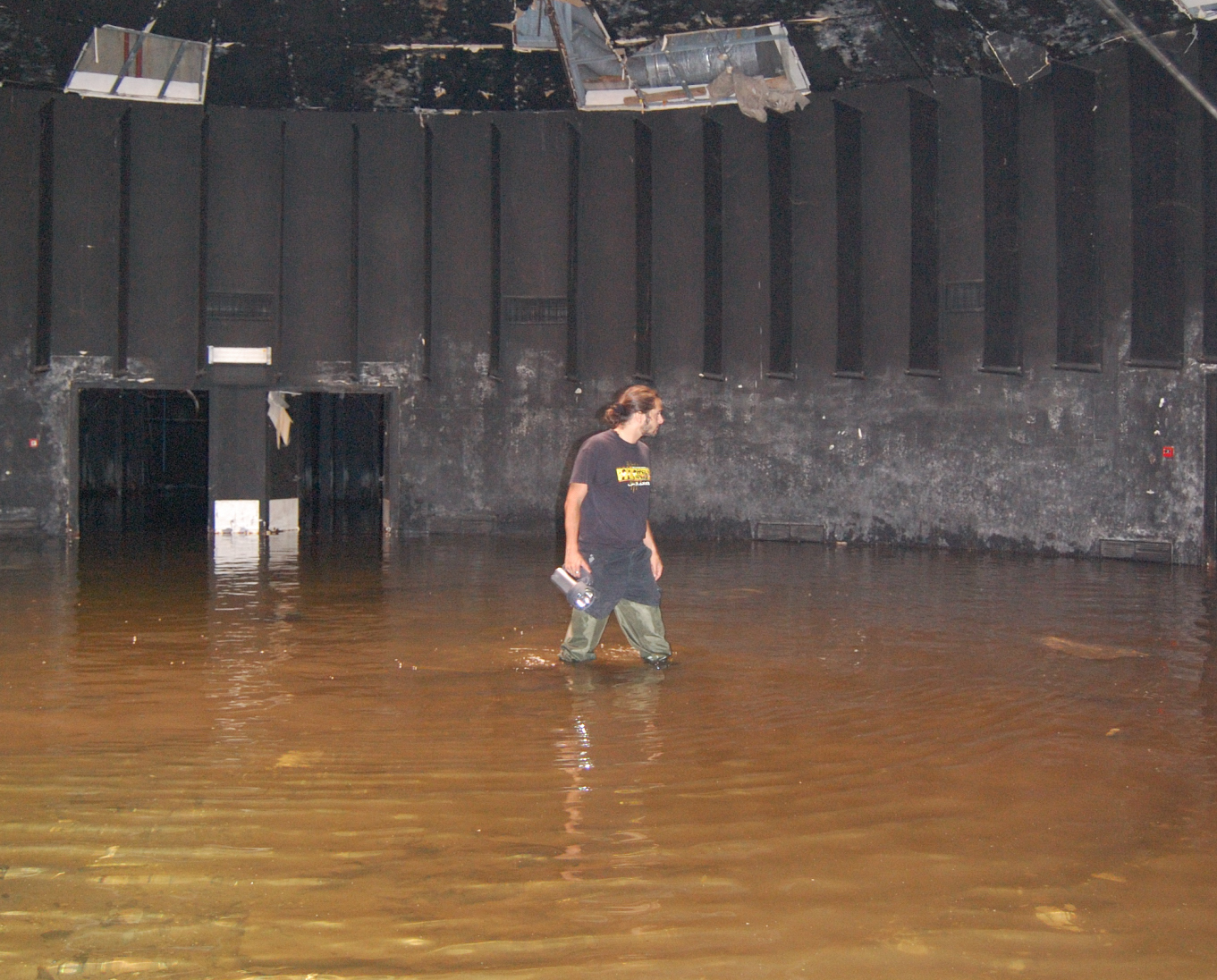
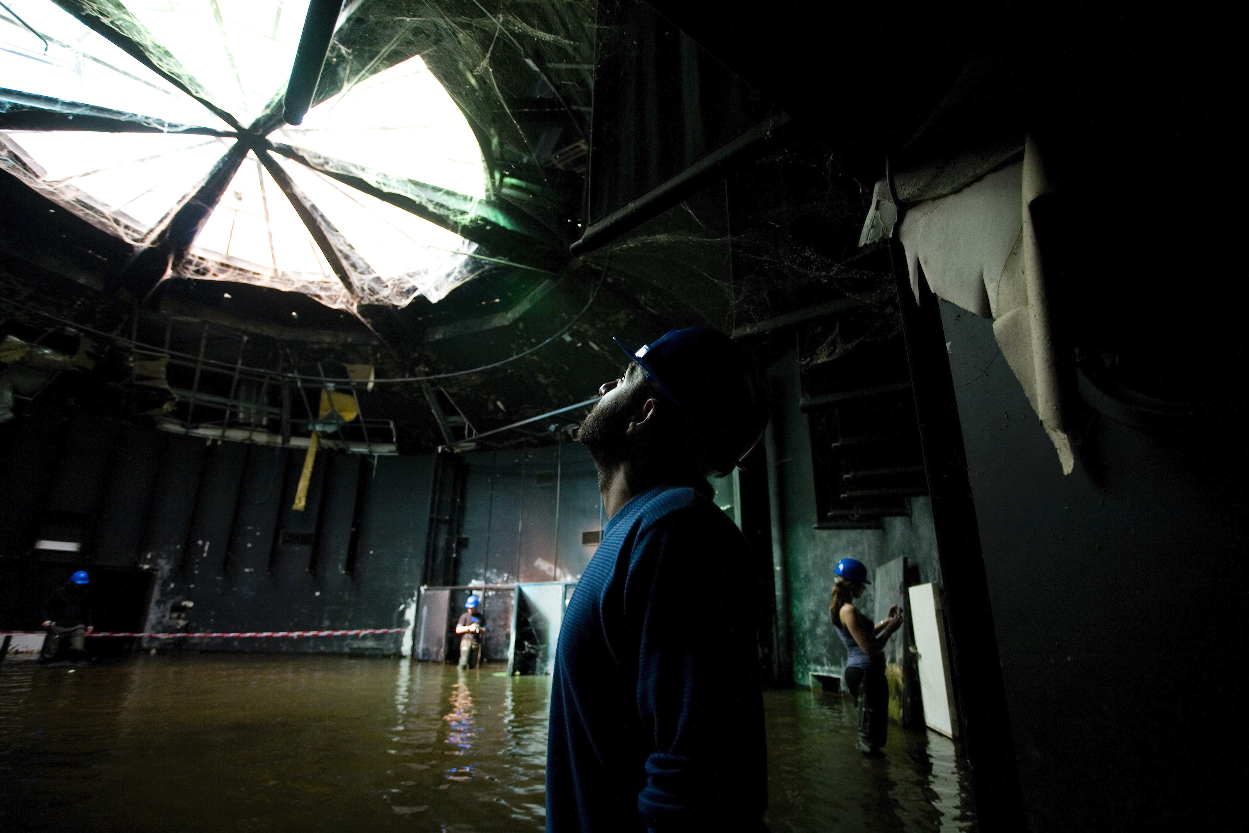
The physical space was the European Pavilion at the Cartuja Technology Park, Seville. The park is the result of the urban recycling of the site of the World Fair held in the city in 1992. Although it is a successful, productive environment, some of the world fair pavilions still stand empty. One such is the European Pavillion, which nowadays looks like a ruin from a novel by J G Ballard: subterranean, empty, partly flooded. The installation in question aims to turn it into a type of visitor’s center for the archaeological exploration of the future.

Europe pavillion

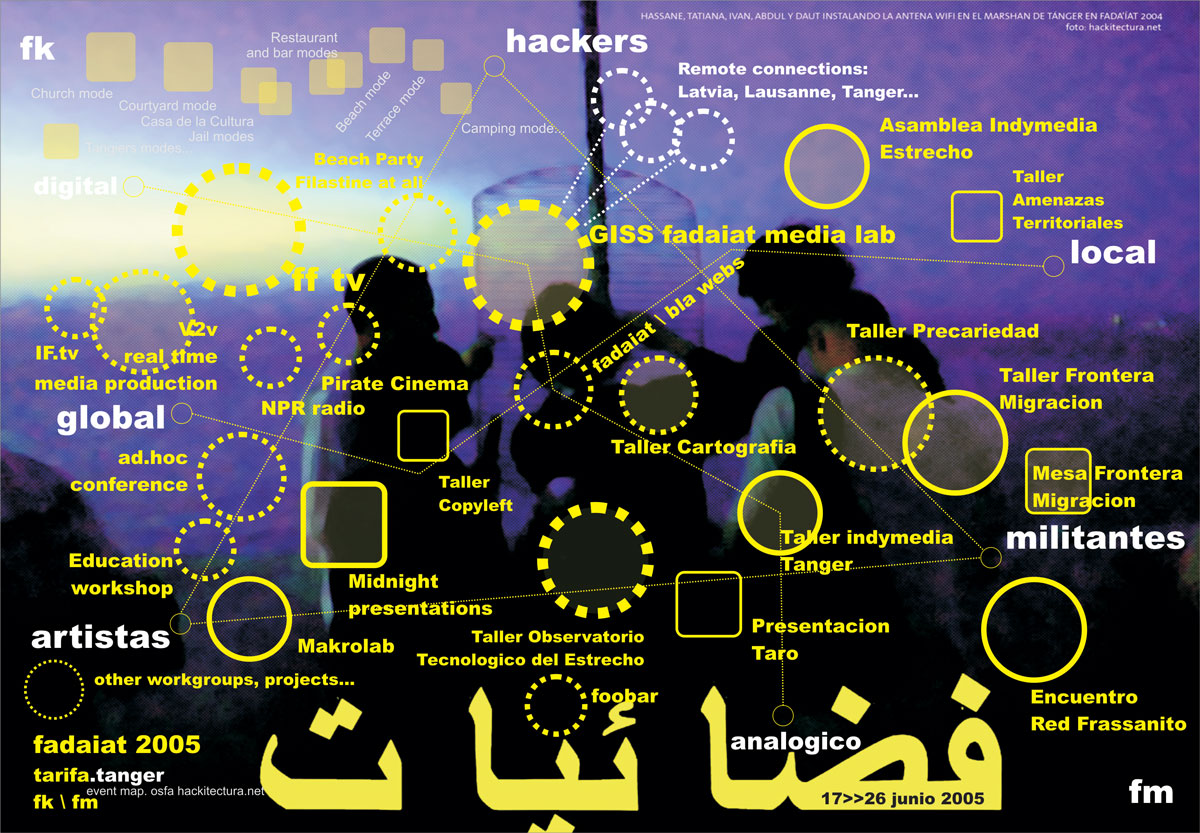
The digital space was a 3D clone of the physical space created in a synthetic or Metaverse world, Open Simulator, which could be described as a free and distributed version of Second Life. This digital space shows environmental data collected from the pavilion in real-time by means of sensors (arduino-squidbee / light, relative humidity, temperature) while simultaneously displaying a project to transform the pavilion into an experimental citizen’s media lab, on the lines of the Prado and Hangar media labs (Madrid and Barcelona).

open simulator

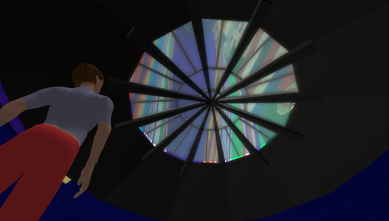
Meanwhile, the process was documented at the Centro Andaluz de Arte Contemporáneo by means of two screens that act like mirrors: one shows the physical space and project details, while the other is an Open Simulator version of the pavilion in the future, which can be toured by visitors.

Installation

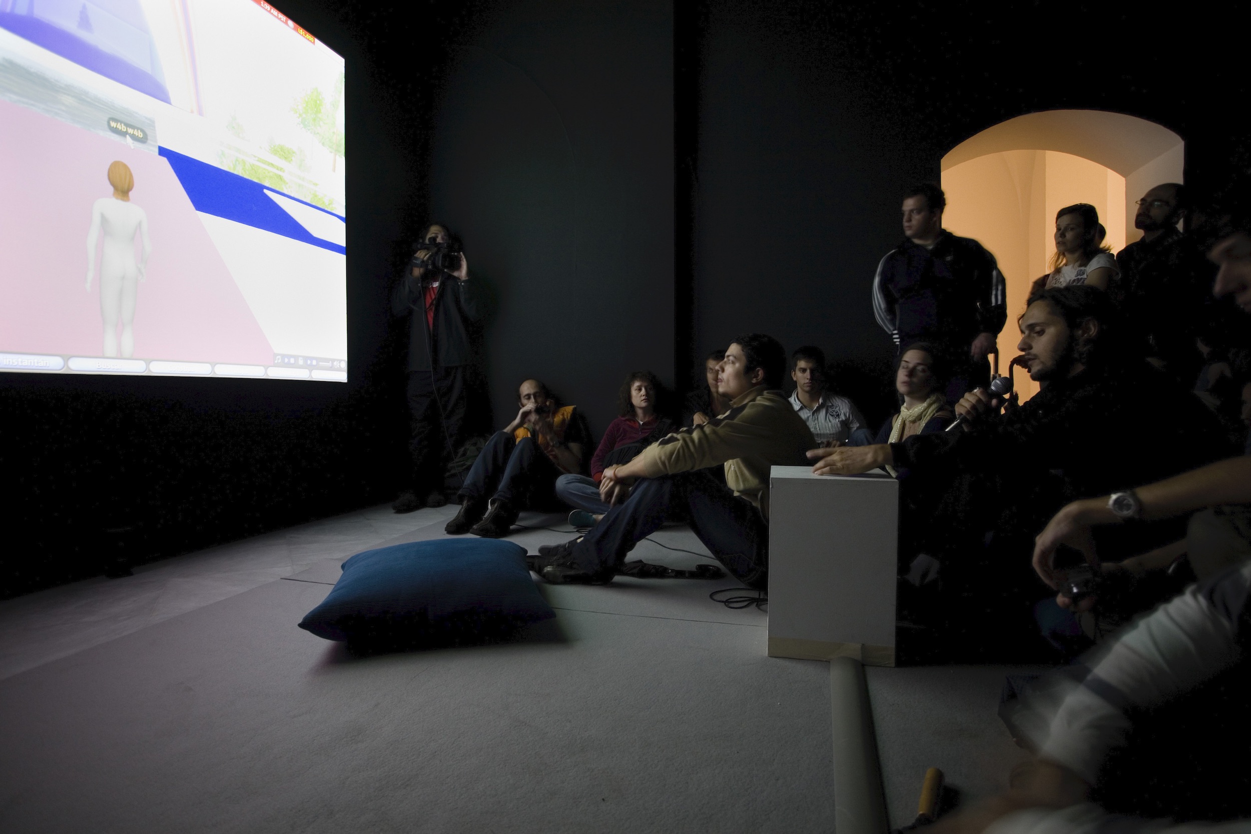
The project raised public awareness about the place as a space of opportunity for Seville and explores its future use as an experimental citizen’s media lab. Digital artists, architects, students and the public were invited to take part in a forum on the participatory construction of the project.

Volver atrás

Critical Cartography of the Straits of Gibraltar

Hackitectura’s map Cartografía Crítica del Estrecho (Cartography of the Straits of Gibraltar) creates an alternative understanding of the Spanish-Moroccan border region. The border is not an abstract geopolitical line but an increasingly complicated, contested space. The inversely oriented (north at the bottom) map highlights connections between southern Spain and northern Morocco to show a single region. A multitude of migrants enters Europe in flows, past motion sensors, semi-military repression and expulsion. The idea of the map is to follow the flows that already traverse the border, such as migrants, Internet data and cell phone calls, as well as capital and police. The flows reshape the very border into a border region. In this mapping project, Hackitectura and their collaborators map the border region to contest and transcend it.

cara a
Volver atrás

Fadaiat: freedom of movement, freedom of knowledge

The straits of gibraltar is a mirror-territory of the transformations taking place in the world today: globalisation, migrations, borders, citizenship, network-society, communication, technologies… the border is a crossed-place, an extensive territory of life and mobile confinements where multiple social practices put pressure on established limits. new spaces and relationships emerge from and through the border between southern europe and northern africa.

the book and all it entails plays an important and irreplaceable role, but it is just a fragment of a process that goes far beyond it in terms of both time and subject matter. Here it opens new possible becomings that were mere conjectures until it was written; it is a line with relative autonomy running parallel to the other relatively autonomous part-projects and establishing fruitful exchanges among them, which in turn become an opportunity for new projects.

through this process, and specially the publishing of this book, we want to contribute to the existence of new spaces of social and technological hybridisations that, by forging new paths, continually (re)invent world(s).

Volver atrás

Gaza cartography

Este trabajo recoge un catálogo de mapas, software y vídeos coordinados de forma narrativa usando tecnologías avanzadas de descripción del espacio (GIS, Software, Modelado 3D) mostrando aspectos que no serían evidentes en una primera lectura. Pueden ser extrapolados a territorios y contextos de paz sujetos a tensiones y transformaciones en que la arquitectura y el urbanismo tengan una importancia relevante.

See atlas https://issuu.com/filoatlas/docs/cartografiando_gaza

Cartografiando Gaza es una prolongación del Taller de Invierno de 2009 del Área de Proyectos Arquitectónicos en la Escuela Politécnica Superior de la Universidad de Alicante y que en la presente edición contó con el comisariado de Régine Debatty, José Pérez de Lama y Pablo de Soto, y la coordinación del catedrático José María Torres Nadal y los profesores Miguel Mesa del Castillo y Juan Carlos Castro.

Volver atrás

Mapping the Commons

A research project and an open urban laboratory to explore that complex concept called the urban commons. The project proposes a method where the commons are discussed, defined with parameters and, sometimes, represented in short videos.

Go to site: http://mappingthecommons.net

Volver atrás

Citizen Cartography International Symposium

El I Encuentro Internacional de Cartografía Ciudadana tuvo lugar en el Paraninfo de la Ciudad de la Cultura y en LABoral Centro de Arte de Gijón entre el 30 de julio y el 1 de agosto de 2009. El encuentro reunió por primera vez bajo esa temática a un amplio grupo de investigadores y activistas de diferentes ámbitos: arquitectura, periodismo, antoprología, urbanismo, prácticas artísticas, geografía, biología, psicología, trabajo social y desarrollo de software. La metodología consistió en presentaciones teóricas y sesiones de trabajo que tuvieron como objetivo el tejer red y combinar esfuerzos y recursos para el desarrollo de un proyectos convergentes de software libre de cartografía ciudadana. Como actividad paralela, llevamos a cabo una deriva por las zonas en transformación de Xixón con la Asociación a Pie de Barrio.
(más…)

Volver atrás

Seville Global Map

In Seville, on the eve of a large EU summit and concomitant protests in 2002, a collaborative mapping project was carried out with different community organizations to try to represent different effects of globalization on the city. The project drew on Zapatista frameworks of understanding, particularly those from the communiqués on “Seven Loose Pieces of the Global Jigsaw Puzzle” (Marcos 1997) and the “Fourth World War” (Marcos 2001). In this case, the map is part of a broader collective project of revisioning the city, a project that lasted much longer than the action itself.

This early mapping projects resembled street maps, although our goal was to chart the diversity of protest actions and events at one of the large anti-globalization protests. Individual groups could plot their different actions on a larger master copy and it could be used as an infopoint at a protest convergence centre or reprinted for handheld use. From these efforts at showing where protests were happening, later efforts focused on how to translate discussions of the effects of “globalization” on a city-wide scale.

Volver atrás

Situation Room

The term Situation Room is normally used to designate a secret place used in times of crisis to assess and monitor data for decision making purposes. Its origins can be traced back to World War II with the invention of computers, digitalization, and the collaboration of architects and the military. These rooms are equipped with monitors and data boards used to control everything from flows crossing the strait of Gibraltar to nuclear fission processes in Nuclear Power plants and the life support mechanisms on board the International Space Station.

Go to book: http://www.dpr-barcelona.com/index.php?/projects/situation-room/

Volver atrás

Technological Observatory of the Straits

Many meetings and workshops organised led to a process of discussion and experimentation that eventually produced the idea of the Technological Observatory of the Straits. Some of the main issues that intersect with the transformations now in process, as discussed above, are beginning to overlap and cross each other, and so common hypotheses are being raised in different collective spaces for theoretical discussion and practice. It is difficult to name and locate all the spaces and times that have shaped the steps of this nomadic path. Conferences, workshops, meetings in person or through chat, celebrations, conversations in different contexts, mobilisations, compilations of material shared on the tiki-wiki, online publications and comments, telephones. Collective paths and also individual paths that converge in Fadaiat and the Observatory, and that we can synthesise for the purposes of this text, without forgetting that the experiences go much further than the text. For us, all these moments of intersection have affective dimensions and intensities that cannot be reversed.

Volver atrás

The connected multitude

The Connected Multitude was a prototype for a networked public space, produced for a network of activists, artists and technicians. Using technologies such as a bi-directional satellite connection, wifi (in its infancy at the time) and streaming with free software, – with real time connections to México DF, Bogotá, Paris or El Viso del Alcor -, we created a space which was both local and global, digital and analog.

Volver atrás

WikiPlaza

WikiPlaza was an experimental, long-term project that brought together several collectives of architects, hackers and activists. The idea sprung up of generating a hybrid public space in which to experiment with information and communication technologies as tools for individual and communal emancipation, based on free software and hardware, web 2.0 tools and an open and transparent use of spaces and systems.

Beginning with a generic discussion of new freedoms in the global metropolis —mobility, flexibility, cyborg transformations, ecology and participation — WikiPlaza Paris project consisted of a series of diagrams that proposed turning the place de la Bastille into a citizenship laboratory in the framework of the network society. Concepts and tools drawn from digital networks —especially from the communities of free software— were applied to the social construction of an open and participative public space that would favor use by its inhabitants. The concepts developed therein recombine ideas and practices most of which are already present on the web. The idea is that, in the construction of a permanent institutional space, we can attempt to bring into play the creative and organizational experiences of social movements over the last decade, including indymedia, hackmeetings, Wikipedia, Fadaiat and Mayday, as well as the more commercial ones from the so-called web 2.0, including Google, Blogger, Flickr, Myspace, Facebook and Youtube, to name but a few of the most outstanding. Continually redrawn from the first stages of work, the conceptual diagrams we seek to apply in the wikiplaza are as follows.

Wikiplaza Paris was set up as part of the Festival Future en Seine. Festival de la Ville Numerique, organised by Paris Cap Digital and curated by Ewen Chardonnet. It operated from 29 May to 7 June, 2009. The project was a co-production between the Cap Digital team, hackitectura.net and the Labomedia, directed by Sergio Moreno from hackitectura.net and Laura Hernández Andrade. It involved a production team of approximately 30 people.
The WikiPlaza has located in Place de la Bastille, one of the emblematic sites in the French capital, and functioned as the main hub of the festival. The architecture was developed by Straddle3 and Hackitectura, and consisted of a geodesic dome with a 15 meter diameter and a height of 7.5 meters, offering a covered area of some 180 square meters. To complement it, we designed a demountable platform based on the Layher system but adapted to the geometry of the prototype, which had to include an access ramp, a bicycle parking area, a ‘quarterpipe’ for skaters and stepped seating, all designed to enhance its integration with the everyday use of the public square. This base also allowed us to counterweigh the structure given that there was an express ban on drilling into the paving in the square. This was done using a sophisticated system of cabling and counterweights beneath the platform. The base and dome were complemented by the Mille Plateaux furniture element designed and digitally fabricated.