Un curador y académico con una experiencia iconoclasta que trasciende las fronteras geográficas y disciplinarias.
Etiqueta: radical cartography
‹ Volver atrás
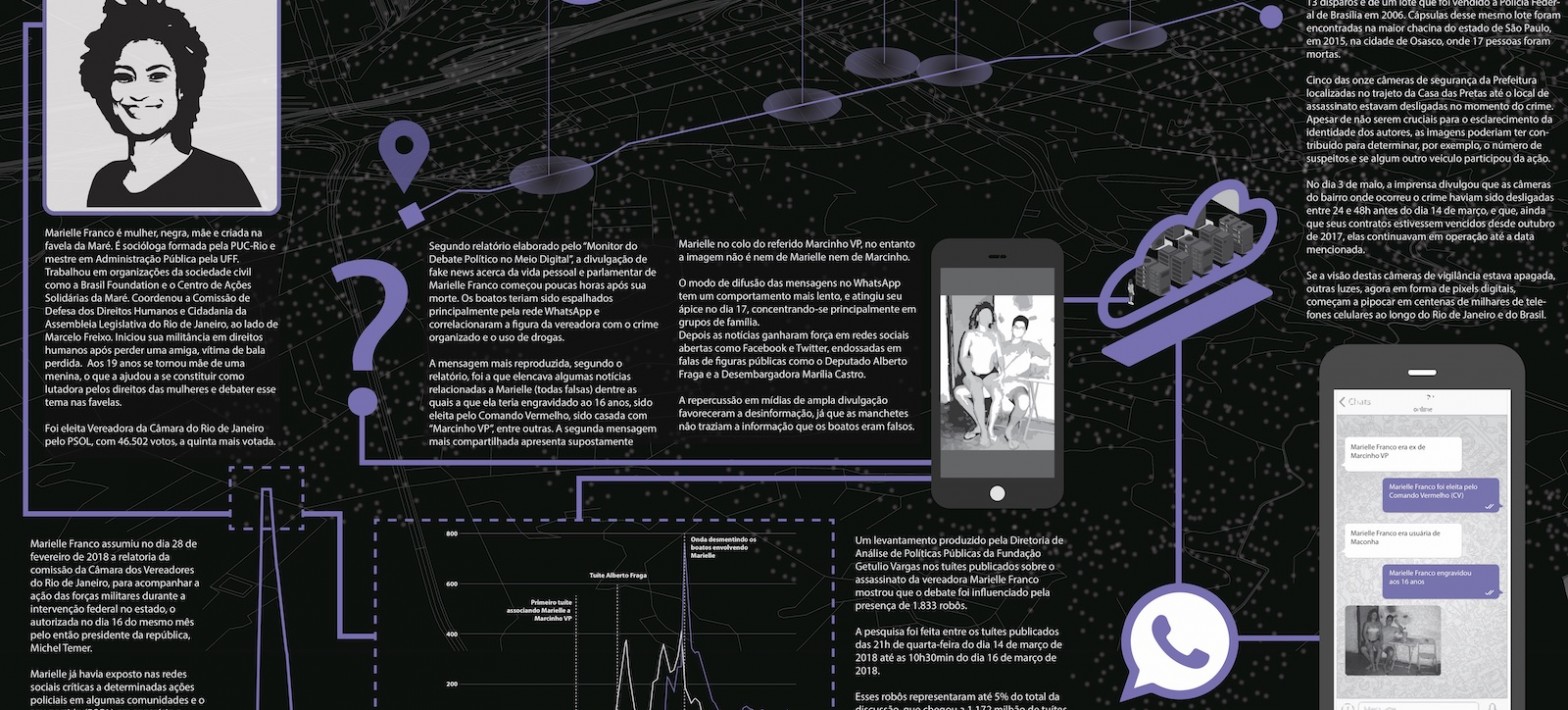
Cartography of a Techno-political Assassination
Cartography of a Physical & Digital Assassination
This project brings a visual exploration of the physical and digital layers surrounding the death of Marielle Franco.
If it was not enough to kill her on the streets, the murder was followed by the attack on her public figure through the circulation of fake news and images in the digital realm.
Using cartography, the project visually presents in the same condensed page the multiple layers and elements involved in the event: human bodies, surveillance cameras, WhatsApp groups, photographs, lethal weapons, urban routes, mobile phone screens, cloned car license plates, and twitter accounts.
The information was collected from the online portals of the newspapers Folha de S. Paulo, O Globo, G1, BBC Brazil, Brasil de Fato, El País, and research institutions: FGV and Monitor Público / USP.
While visualizing these heterogeneous elements altogether, we started to grasp a complex story of two instruments of assassination, its physical violence and the digital infrastructures and procedures that made it possible.
—
Cartografia de un Assassinato Físico & Digital
Este projeto traz uma exploração visual da morte de Marielle Franco, tratando-o como um acontecimento duplo no espaço físico e digital.
Se não foi suficiente o assassinato na rua, a morte da vereadora foi seguida do ataque à sua figura pública através da circulação, poucas horas depois de sua morte física, de boatos e fotos falsas na esfera digital.
Com a utilização da cartografia, o projeto apresenta em um mesmo plano condensado as múltiplas camadas, elementos e eventos envolvidas na dupla morte: corpos humanos, câmeras de vigilância, grupos de whatsapp, fotografias, armas letais, percursos urbanos, telas de celular, placas de carro clonadas e contas de twitter.
As informações foram coletadas, até novembro de 2018, dos portais online dos jornais Folha de S. Paulo, O Globo, G1, BBC Brasil, Brasil de Fato, El País e de instituições de pesquisa: FGV e Monitor Público/USP.
Ao visualizarmos esses elementos heterogêneos justapostos, começamos a compreender uma história complexa de dois instrumentos de assassinato, sua violência física e as infra estruturas e procedimentos digitais que tornaram isso possível.
Principal Investigator: Pablo DeSoto Investigators: Alice Piva & Lucas Rolim
To be presented at Festival3i Rio de Janeiro, 20/10/2019.
‹ Volver atrás
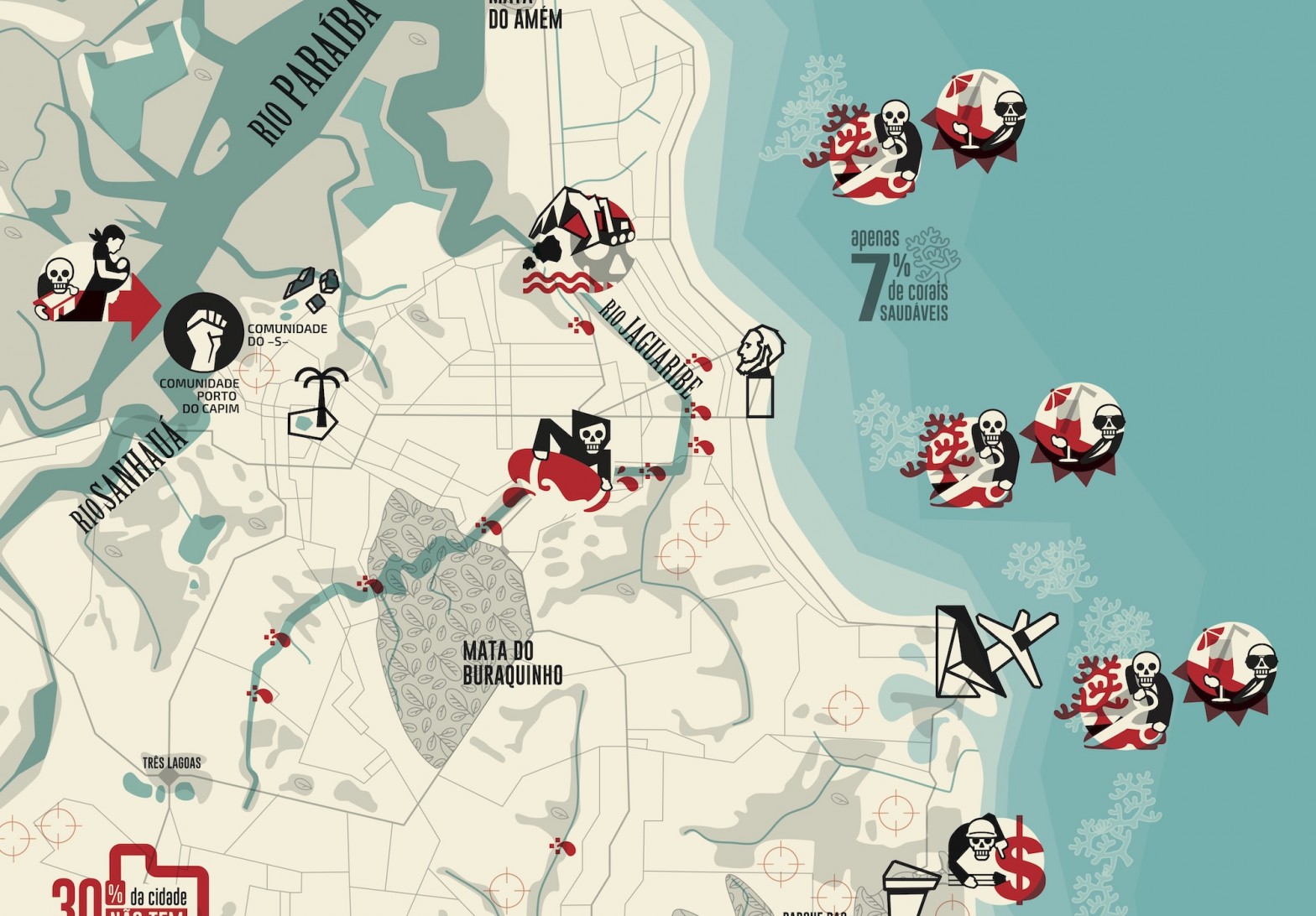
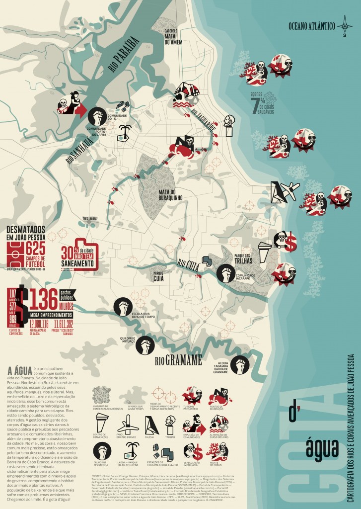
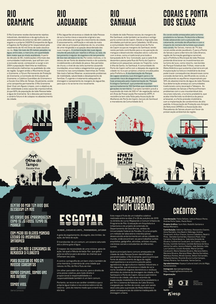
Cartography of endangered Rivers and Corals
CARTOGRAFIA DOS RIOS E CORAIS AMEAÇADOS DE JOÃO PESSOA
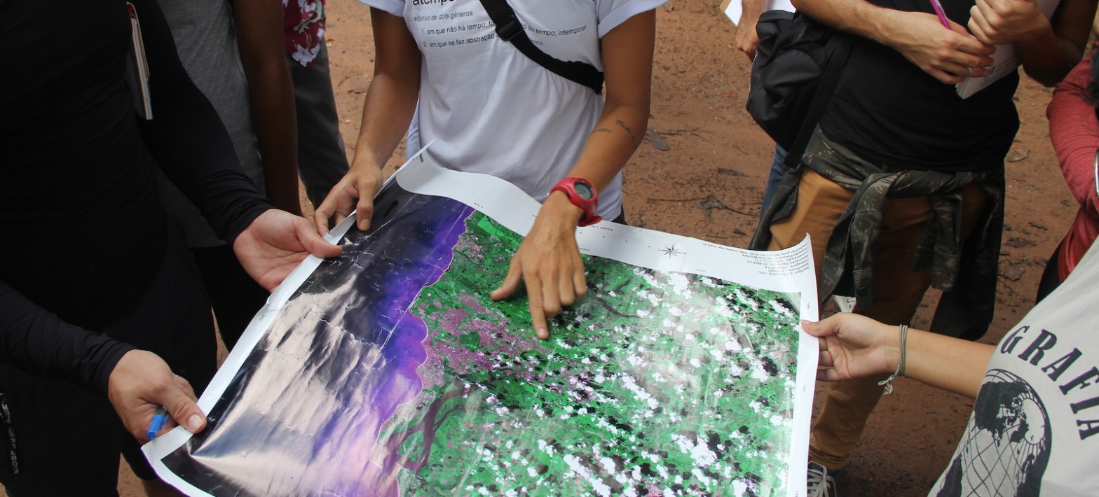
A ÁGUA é o principal bem comum que sustenta a vida no Planeta. Na cidade de João Pessoa, no Nordeste do Brasil, existe em abundância, escoando pelos seus aquíferos, mangues, rios e litoral. Mas, em prol do lucro e da especulação imobiliária, esse bem comum está ameaçado: o sistema hidrológico da cidade caminha para um colapso. Os rios estão poluídos. Apenas 70% da cidade está conectada à rede de esgoto. A gestão negligente dos corpos d’água causa sérios danos à saúde pública e prejuízos aos pescadores artesanais e comunidades ribeirinhas, além de comprometer o abastecimento da cidade. No mar, os corais, nosso bem comum mais precioso, estão ameaçados pelo turismo descontrolado, o aumento da temperatura do Oceano e a erosão da Barreira do Cabo Branco. A natureza da costa vem sendo eliminada sistematicamente para alocar projetos megalomaníacos que drenam o dinheiro público e causam a perda de habitat para a vida animal e vegetal. E os pobres são os que mais sofrem com esses problemas ambientais. Chegamos ao limite.
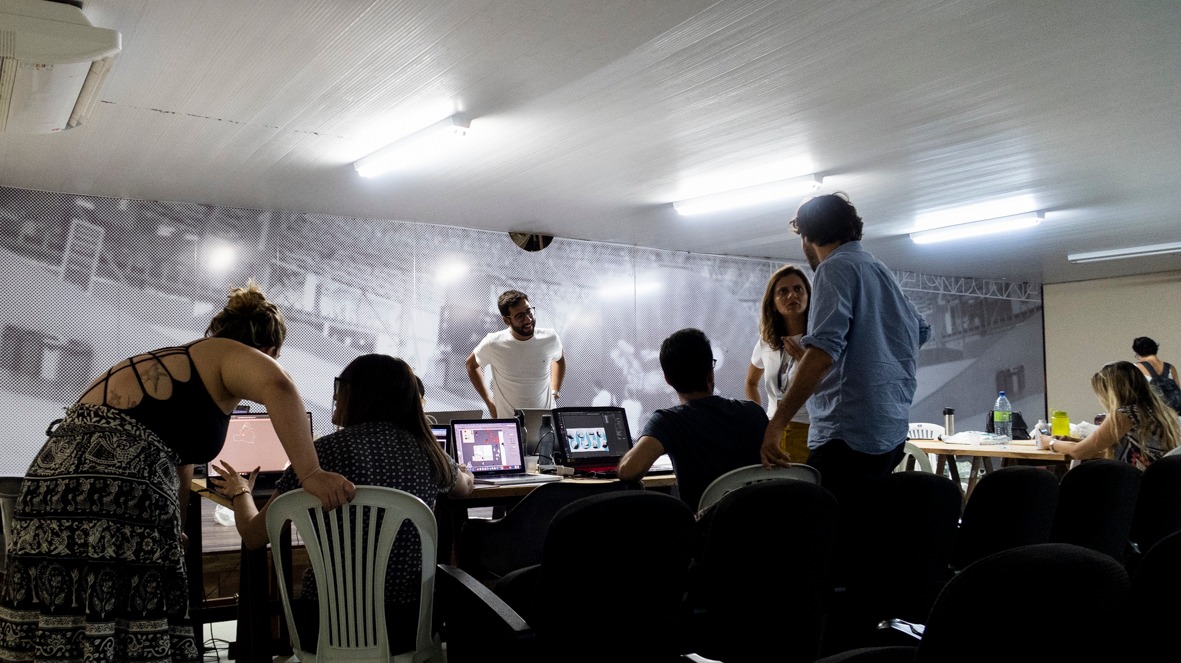
Este mapa é fruto de um trabalho coletivo começado entre os dias 21 e 26 de outubro de 2019 no âmbito dos cursos Mapeando o Comum Urbano e Tópicos Especiais em Urbanismo do DAU e do Programa de Pós-Graduação em Arquitetura e Urbanismo, e do projeto de extensão do Departamento de Geociências, ambos da Universidade Federal da Paraíba. O curso propôs um método de laboratório interdisciplinar, desenvolvido anteriormente em várias cidades do mundo, onde encontram-se para trabalhar juntos arquitetos, geógrafos, ativistas, artistas visuais, cientistas sociais e estudantes de diferentes áreas de conhecimento. Quatro principais bens comuns ameaçados da cidade de João Pessoa foram identificados e parametrizados: o Rio Gramame, que é a principal fonte de abastecimento de água da região metropolitana, se encontra poluído pelos agrotóxicos da agricultura e rejeitos industriais; o Rio Jaguaribe, que atravessa a cidade de sul a norte recebendo esgotos domésticos e resíduos depositados de modo irregular no sistema de drenagem da cidade; o Rio Sanhauá e o Porto do Capim, berço e patrimônio histórico da cidade, são alvos recentes da especulação imobiliária e do turismo predatório; e por fim, o sistema de falésias do Cabo Branco, que é margeado pelo terceiro maior recife de corais do mundo, e que vem sendo destruído pela supressão da mata atlântica e um sistema inadequado de drenagem.
Coordenação: Pablo DeSoto, Letícia Palazzi Perez, Andrea Porto Sales, Paulo Rossi. Projeto gráfico: Yumi Nsh, Rodolfo Santana, Raissa Monteiro. Contribuiram: Flavia Bezerra, Gabriella Almeida de Oliveira, Ian Coelho, João Luiz Carolino, Lincoln Almeida, Mariana Oliveira, Yanna Garcia, Aurora Caballero, João Batista, Aurora Caballero, Raissa Monteiro, Adelmar Barbosa, Andrea Cavalcanti, Arthur Chacon, Ricardo Bruno Cunha Campos, Danielle Guimarães, Eleonora Paoli, Maria Carmen Cavalcanti, Mariana Daltro, Rafaella Dantas, Beatriz Pires, Elisa Carneiro, Matheus Pontes, Aline Ramalho, Ana Beatriz Nóbrega, Ivana Accioly, Jessica Rabello, Ivanildo Santana, Jailma Carvalho, Izanilde Barbosa da Silva, Alessandra Soares, Guilherme Cavalcanti, Maria Heloísa Oliveira, Mariana Ribas, Marilia Dornellas, Mirelli Gomes, Nilton Fernandes, Sidney Pereira & Yan Azevedo. Organização: PPGAU e DGEOC, Universidade Federal da Paraíba. Agradecimentos: Espaço Cultural José Lins Do Rego, Pedro Rossi, Iconoclasistas. Apoio: IESP. instagram @projetogotadagua
‹ Volver atrás
Mapeando o Comum Urbano
Universidade
UFPB PPGAU
Código
SPPGAU5002 – T01 e SPPGAU5002 – T02
Professores
Pablo DeSoto & Leticia Palazzi + Andrea Porto DGEOC (Departamento de Geociências) & Paulo Rossi IESP (Instituto de Educação Superior da Paraíba) (colaboradores)
Créditos/carga horária
4Cr/60h (Pos), 3Cr/45h (Graduaçao)
Semestre
2019.2
Datas/Horario
21 a 26 de Outubro, 16 a 22 h
Local
Fundação Espaço Cultural José Lins do Rego
EMENTA
Curso teórico-pratico de exploração, discussão e mapeamento dos bens comuns urbanos ou comum urbano (urban commons). Toma a forma principal de laboratório inter-disciplinar onde encontram-se para trabalhar juntos arquitetos, geógrafos, ativistas, artistas visuais, científicos sociais e estudantes de diferentes disciplinas. O curso propõe um método de laboratório, desenvolvido anteriormente em varias cidades do mundo e ganhador do Premio Elinor Ostrom por a Universidade de Buenos Aires, no qual o comum urbano é estudado, parametrizado e apresentado em formato visual e cartográfico. O laboratório abrange a grande João Pessoa como objeto de estudo para a produção de uma contra-cartografia em grande formato sobre seus bens comuns da área metropolitana, que possa contribuir como dispositivo publico nas discussoes e conflitos em andamento.
Estudo dirigido – 27 Agosto a 12 Outubro. Online. Leitura e análise dos livros e artigos principais da bibliografia.
Aulas teóricas e Laboratório de cartografia. – 21 a 25 de Outubro. Espaço Cultural, 16 a 22h. Aula 1: contra-cartografia. Aula 2: comum. Aula 3: cidade.
Intervençao urbana – 26 de Outubro. Corais de Seixas.
BIBLIOGRAFIA
DeSoto, P., Delinikolas, D., Dragona, D., Senel, A. and Pérez de Lama, J.P. 2015. Mapping the Urban Commons: a Parametrical and Audiovisual Method. V!RUS, 11.
Halder, S., e Kollektiv Orangotango, orgs. This Is Not an Atlas: A Global Collection of Counter-Cartographies. First edition. Social and Cultural Geography, Volume 26. Bielefeld: transcript, 2018.
Hardt, M., Negri, A. Bem Estar Común. 2016.
Harvey, D. Ciudades rebeldes. Del Derecho de la ciudad a revolución urbana. 2012
Resultados
Quatro principais bens comuns ameaçados da cidade de João Pessoa foram identificados e parametrizados no Curso: o Rio Gramame, que é a principal fonte de abastecimento de água da região metropolitana, se encontra poluído pelos agrotóxicos da agricultura e rejeitos industriais; o Rio Jaguaribe, que atravessa a cidade de sul a norte recebendo esgotos domésticos e resíduos depositados de modo irregular no sistema de drenagem da cidade; o Rio Sanhauá e o Porto do Capim, berço e patrimônio histórico da cidade, são alvos recentes da especulação imobiliária e do turismo predatório; e por fim, o sistema de falésias do Cabo Branco, que é margeado pelo terceiro maior recife de corais do mundo, e que vem sendo destruído pela supressão da mata atlântica e um sistema inadequado de drenagem.
O curso culminou em uma ação direta de cidadania que foi realizada durante a manhã do sábado 26 de Outubro nas “Piscinas Naturais de Corais da Praia do Seixas”, que situa-se no litoral sul e fica em frente à “Falésia do Cabo Branco” e ao Farol do Cabo Branco e à Estação Cabo Branco – Ciência, Cultura e Artes.
‹ Volver atrás
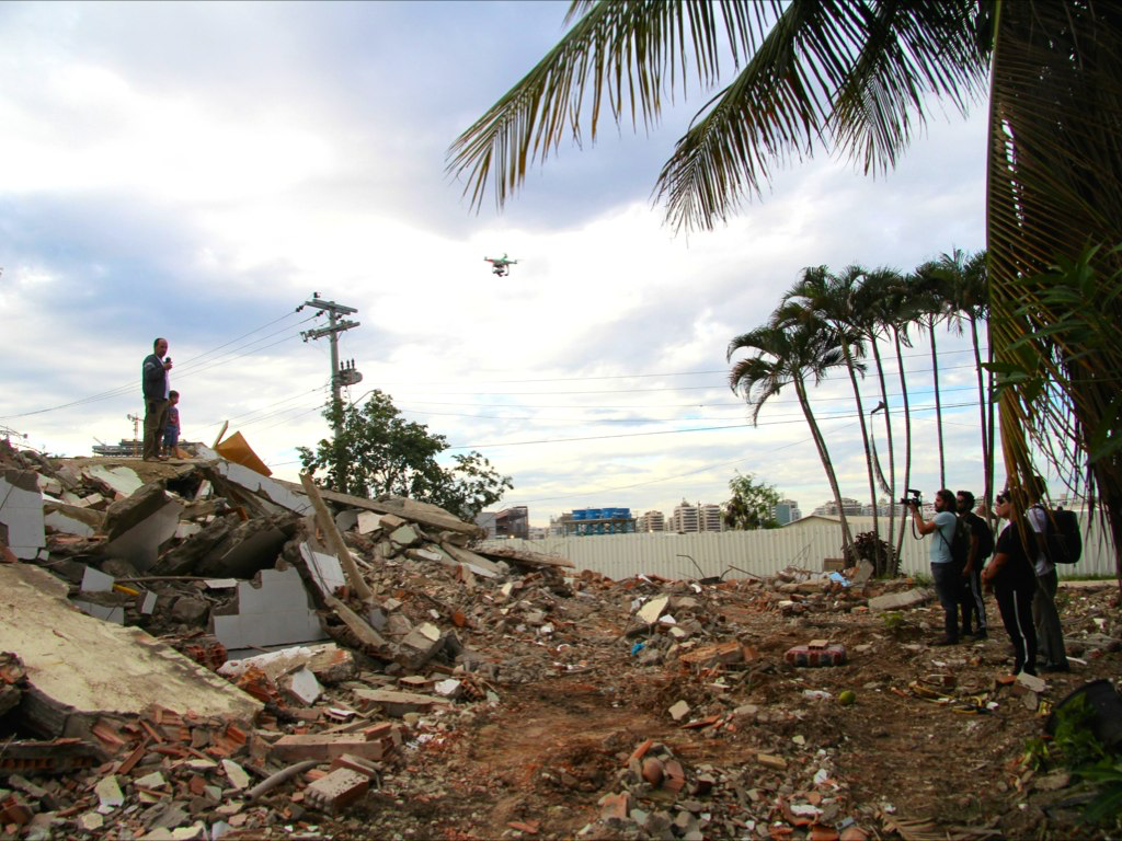
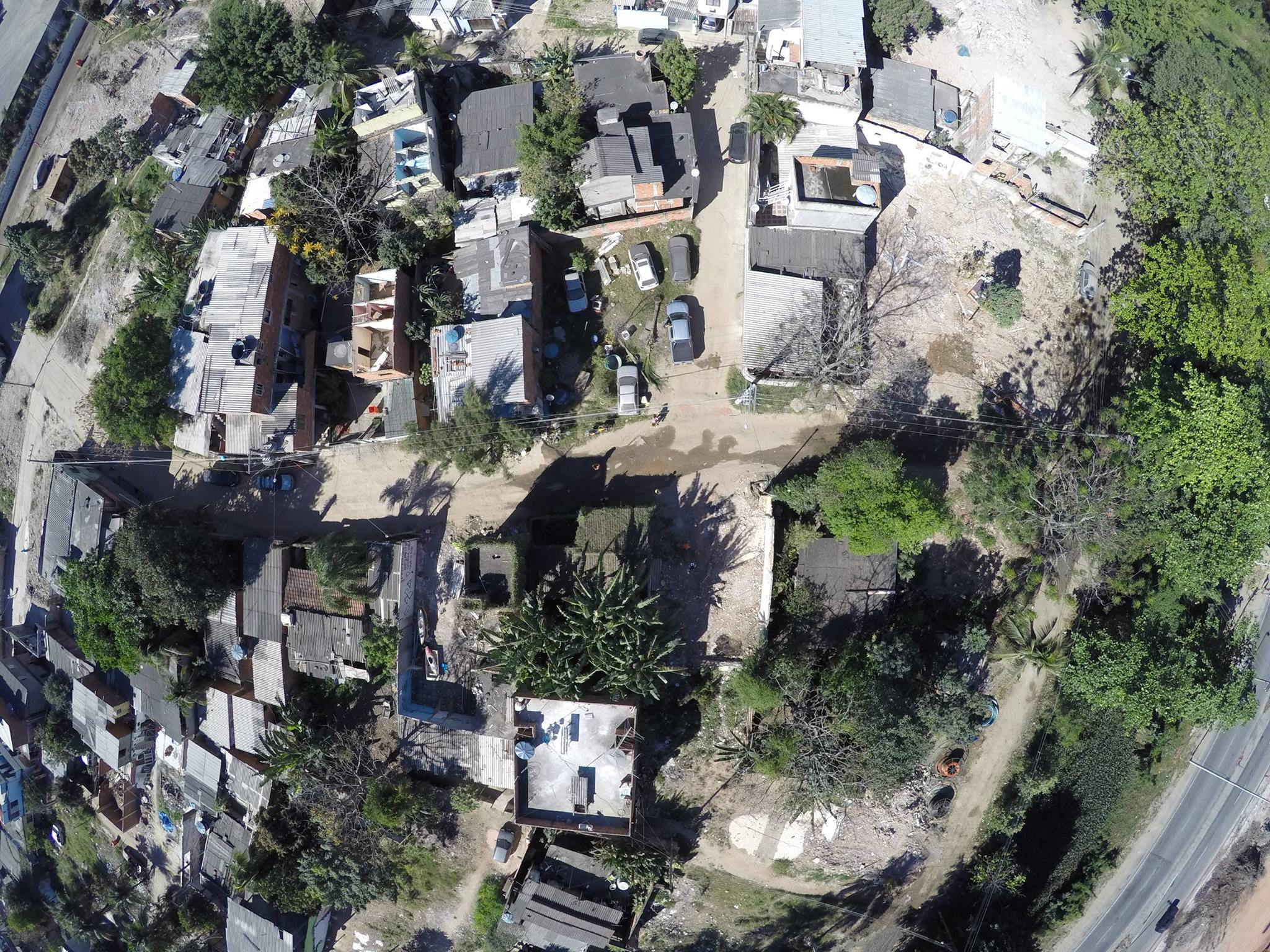
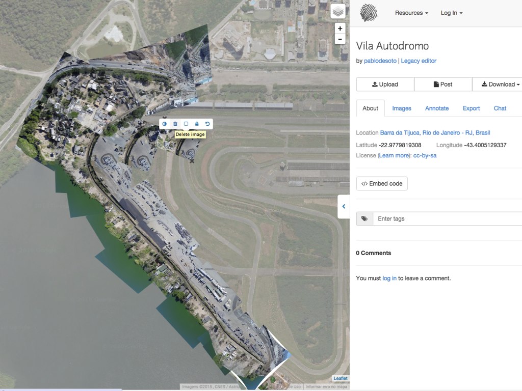
Aerial mapping of Vila Autodromo
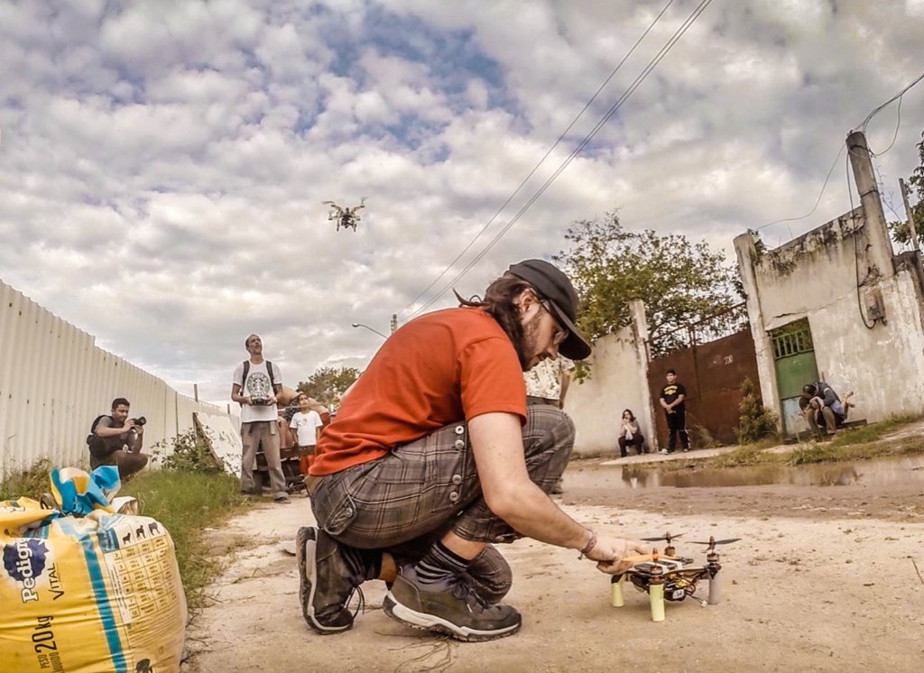
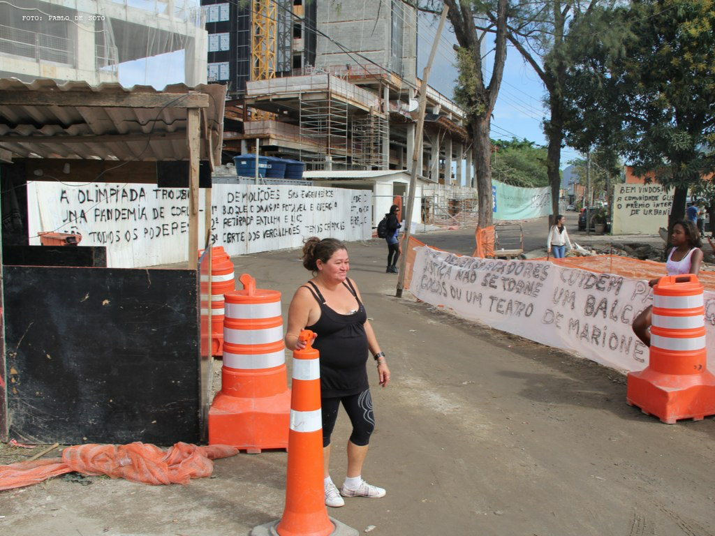
Si la visión aérea, además de en ámbitos militares es utilizada extensivamente por los actores del desenvolvimiento del modelo de ciudad neoliberal: constructor, promotor, prefecto; la actividad de la #DroneHackademy en el contexto metropolitano fue producir una cartografía aérea que visualizara la violencia inmobiliaria y los cercamientos de los bienes comunes: levantar el vuelo allí donde está el conflicto.
Aprendiendo de destacados proyectos como Arquitectura Forense, #DroneHackademy pretende intervenir en el durante, antes de que todo haya sido destruido, expropiado o privatizado, cuando el último capítulo de la vida de las criaturas y los espacios envueltos aun no haya sido escrito.
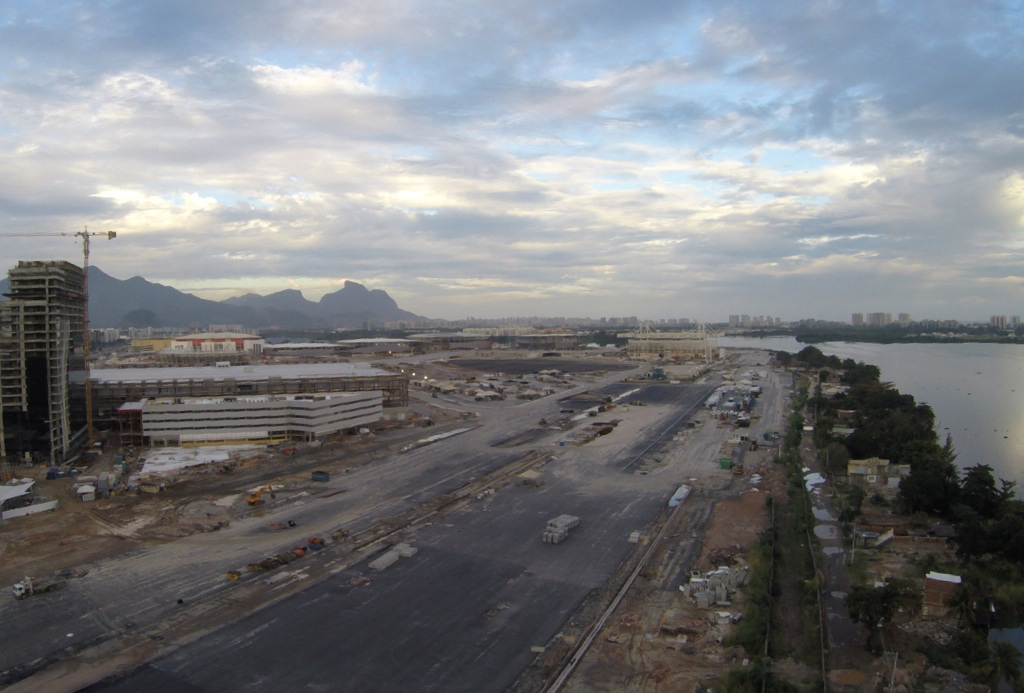
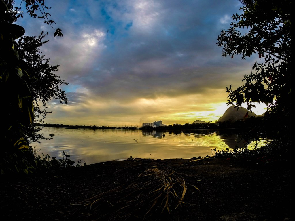
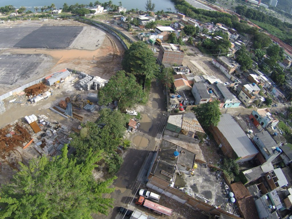
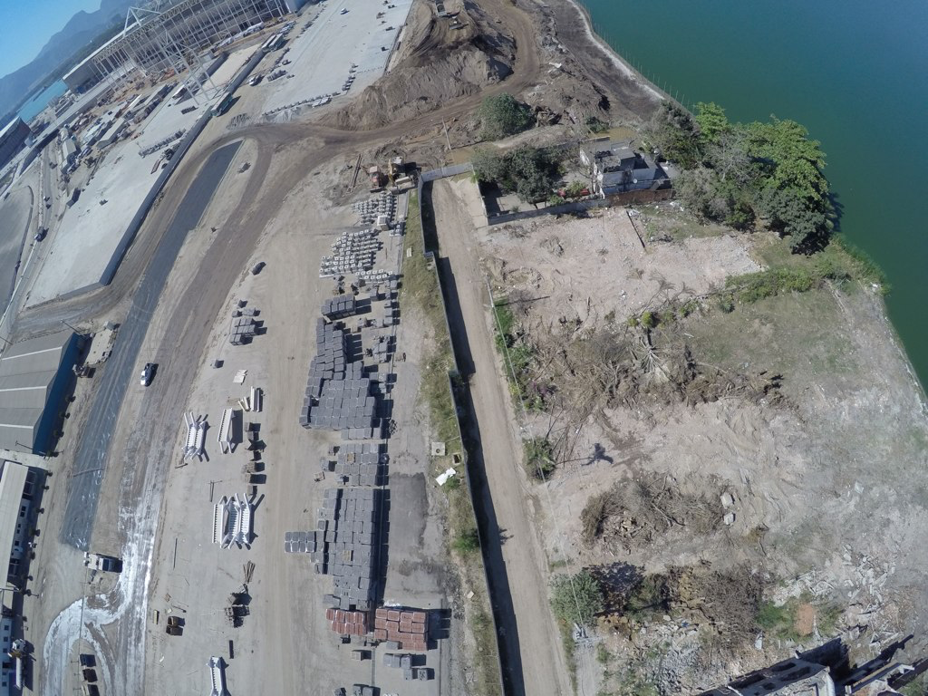
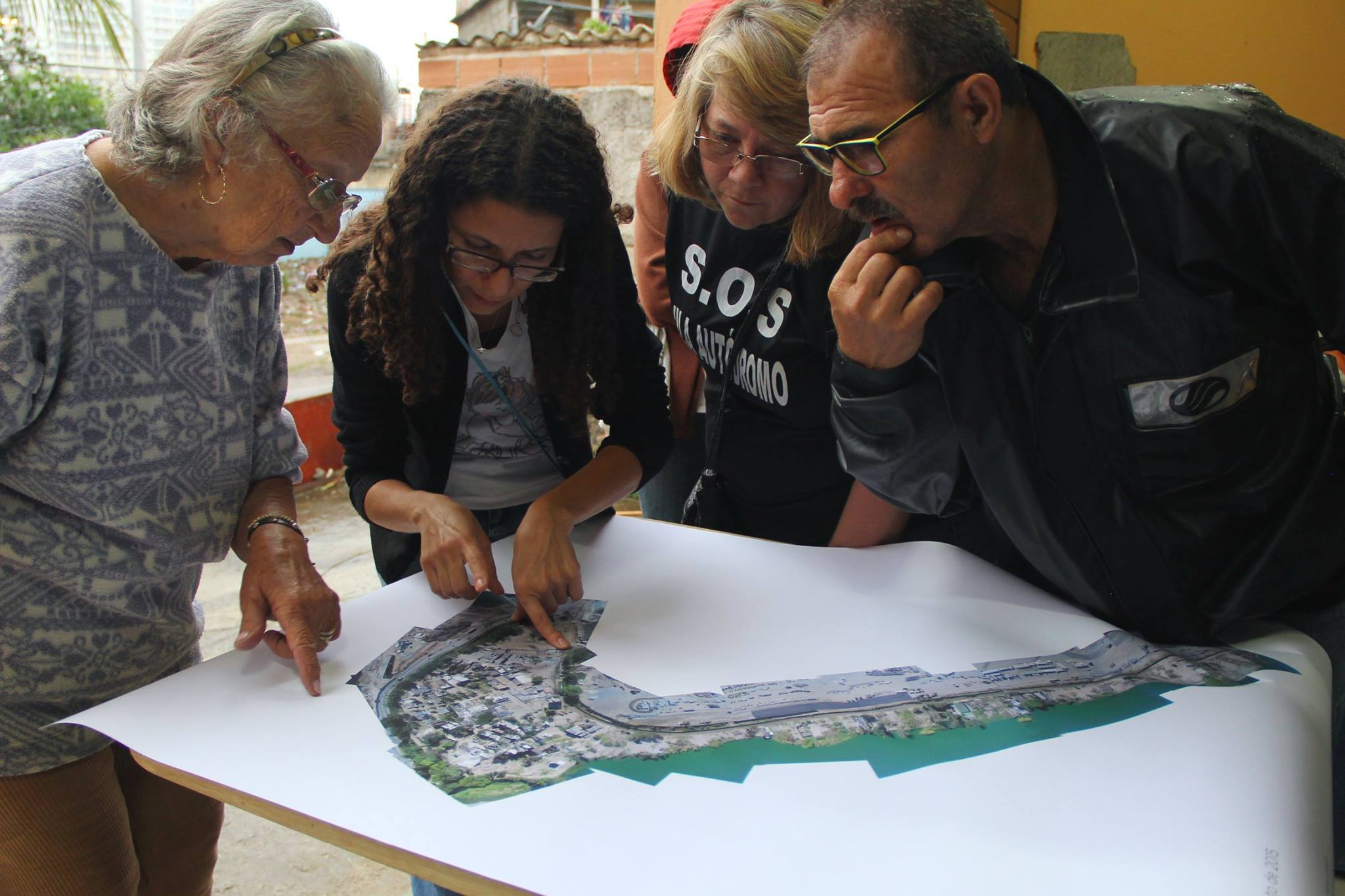
El lugar escogido en Río de Janeiro para levantar el vuelo fue la Vila Autódromo, una comunidad auto-construida y auto-urbanizada, originalmente un pueblo de pescadores, que existe en el borde de la laguna Jacarepaguá/Barra de Tijuca por más de 40 años.
La comunidad conquistó los títulos de propiedad de la tierra, y el derecho a la vivienda reconocidos en la Constitución de Brasil. Desde los años 90 la comunidad está amenazada de desahucio por la Prefectura de Rio, bajo las más diversas razones presentadas.
Como la aldea Gala de Asterix e Obelix con la que en ocasiones es comparada, la Vila resiste desde hace años las tentativas invasoras de la alianza de promotores y gobierno local, las formaciones depredadoras de las élites como definidas por Saskia Sassen en Expulsiones: Brutalidad y Complejidad en la Economía Global.
Actualmente se encuentra al lado de donde se está construyendo el Parque Olímpico, un emprendimiento inmobiliario de la Prefectura en colaboración con tres de las mayores constructoras de Brasil: Andrade Gutierrez, Carvalho Hosquen, Odebrecht -estas dos últimas condenadas por trabajo esclavo en las obras de la Vila Olímpica- en la que es la mayor área de expansión del mercado inmobiliario de la ciudad.
Con todas las transformaciones en marcha, las constantes demoliciones4, y las obras que dificultan la vida diaria de los residentes, 100 de 600 familias resistían en agosto de 2015 el proceso total de desapropiación de su comunidad. Cuentan con el apoyo jurídico del Núcleo de Tierras de la Defensoría Pública, técnicos de dos universidades públicas y de diversos movimientos sociales.
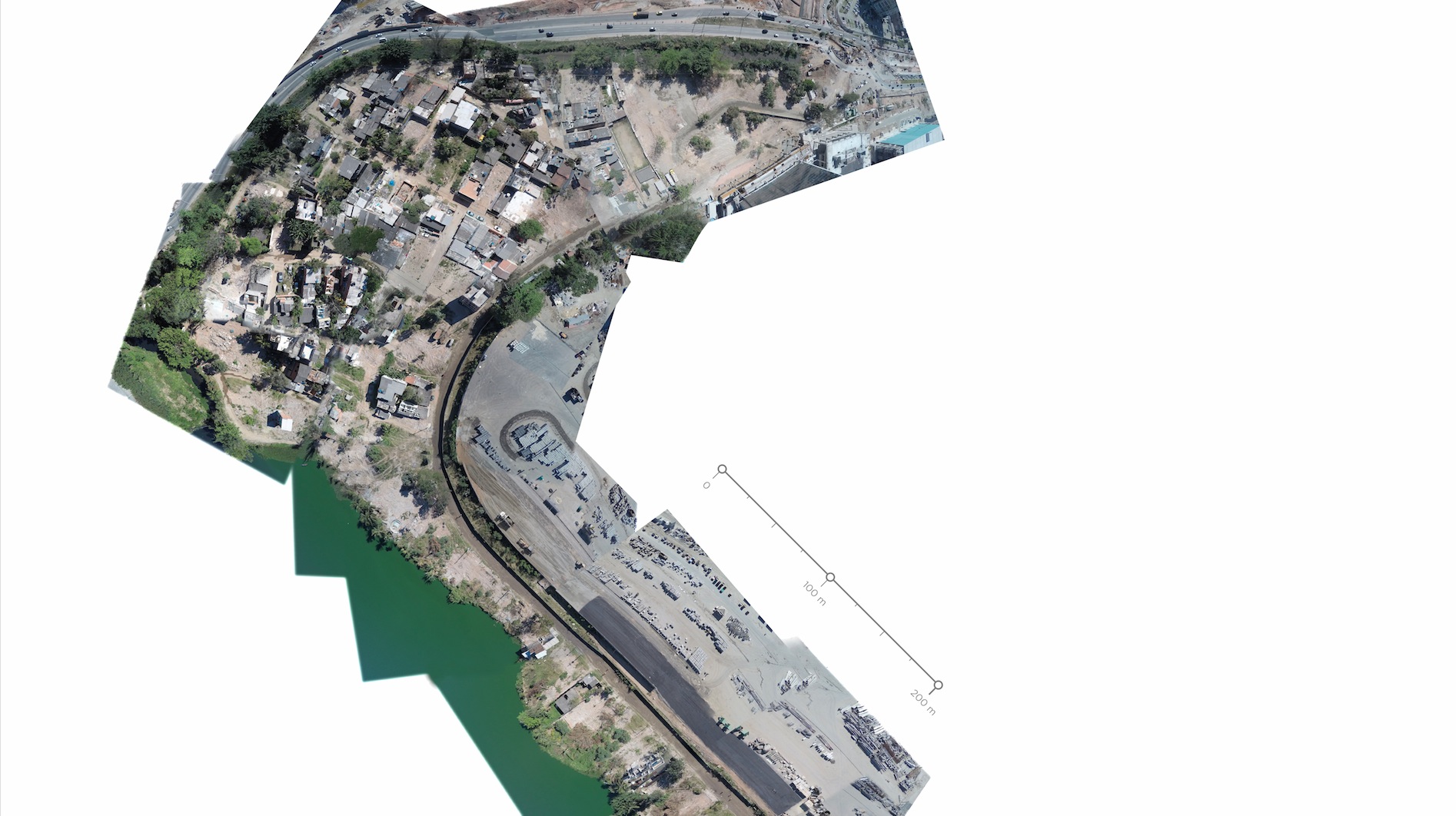
La cartografía aérea de la Vila Autódromo fue realizada a partir de 20 fotografías seleccionadas de más de mil doscientas que fueron tomadas con un quadricóptero a una altitud de 200 a 300 metros entre 9 y 11 horas de la mañana del 15 de agosto de 2015, el día que los moradores organizaron un festival cultural llamado #OcupaVilaAutódromo.
La fotografía de alta resolución fue compuesta con la herramienta online Mapknitter de Public Lab, una organización y red abierta de ciencia ciudadana.
En un acto público celebrado en septiembre de 2015 en la Vila, la cartografía fue entregada a los vecinos y a las redes de apoyo con el fin de explorar el uso de la fotografía aérea en los procesos de abogacía popular y la defensa del derecho a ciudad de la comunidad local.
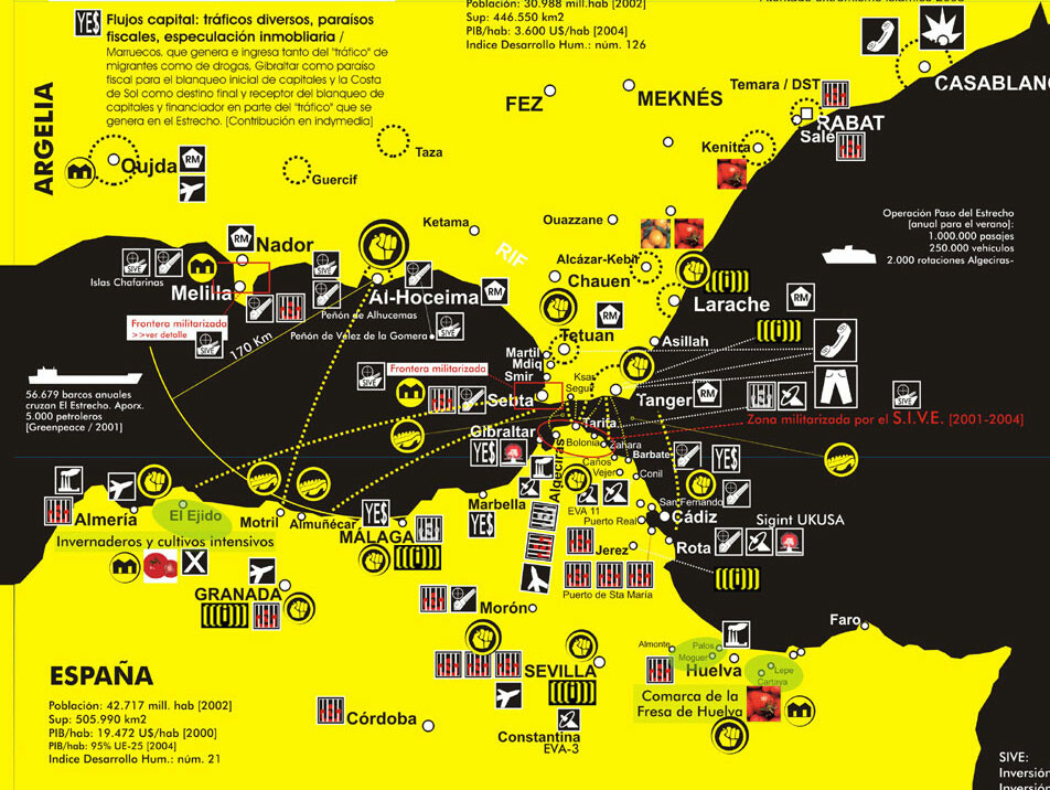
Hackitectura’s map Cartografía Crítica del Estrecho (Cartography of the Straits of Gibraltar) creates an alternative understanding of the Spanish-Moroccan border region. The border is not an abstract geopolitical line but an increasingly complicated, contested space. The inversely oriented (north at the bottom) map highlights connections between southern Spain and northern Morocco to show a single region. A multitude of migrants enters Europe in flows, past motion sensors, semi-military repression and expulsion. The idea of the map is to follow the flows that already traverse the border, such as migrants, Internet data and cell phone calls, as well as capital and police. The flows reshape the very border into a border region. In this mapping project, Hackitectura and their collaborators map the border region to contest and transcend it.
cara a
‹ Volver atrás
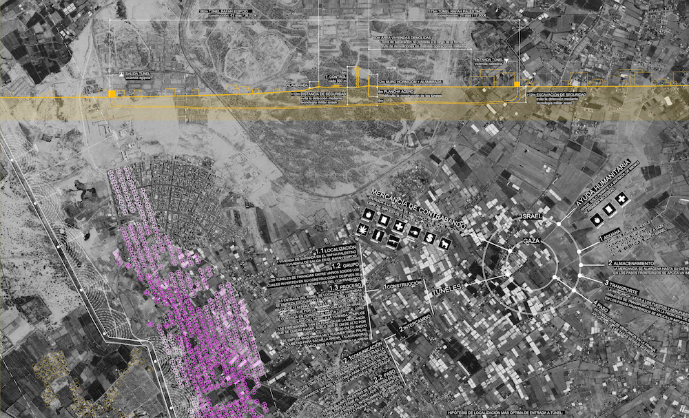
Gaza cartography
Este trabajo recoge un catálogo de mapas, software y vídeos coordinados de forma narrativa usando tecnologías avanzadas de descripción del espacio (GIS, Software, Modelado 3D) mostrando aspectos que no serían evidentes en una primera lectura. Pueden ser extrapolados a territorios y contextos de paz sujetos a tensiones y transformaciones en que la arquitectura y el urbanismo tengan una importancia relevante.
Cartografiando Gaza es una prolongación del Taller de Invierno de 2009 del Área de Proyectos Arquitectónicos en la Escuela Politécnica Superior de la Universidad de Alicante y que en la presente edición contó con el comisariado de Régine Debatty, José Pérez de Lama y Pablo de Soto, y la coordinación del catedrático José María Torres Nadal y los profesores Miguel Mesa del Castillo y Juan Carlos Castro.
‹ Volver atrás
Mapping the Commons
A research project and an open urban laboratory to explore that complex concept called the urban commons. The project proposes a method where the commons are discussed, defined with parameters and, sometimes, represented in short videos.
Taller de videocartografía metropolitana, Medellín
“Los suburbios de las ciudades del tercer mundo son el nuevo escenario geopolítico decisivo”
Mike Davis (Planet of Slums)
“Sea arte, sea deporte, sea de la manera que sea, queremos seguir arrebatando jóvenes a la violencia. Medellín no está lleno de sicarios, esto está lleno de talento urbano.”
Falco (artista hip hop, Comuna de Moravia)
El taller de videocartografia metropolitana tuvo lugar en el contexto del encuentro LabSurlab en la ciudad de Medellin. LabSurlab fue un encuentro de la red de iniciativas independientes que conforman: hacklabs, hackerspaces, medialabs y todo tipo de laboratorios y colectivos biopolíticos operando desde y hacia territorios del Sur [de America] buscando desde la experimentación y creacion lograr sus propios espacios de acción y representación. En palabras de los organizadores: «Uno sobre otro para decantar así los vectores y posibles estrategias culturales de la sociedad red. ¿Por qué? la razón es bien simple, Medellín vive una vertiginosa transformación, existe una gran apuesta hacia lo tecnológico; la cual queremos, debemos, es nuestro interés repensar a partir de la componente experimental, artística y social de los medios.»
El encuentro tuvo como espacio principal el Museo de Arte Moderno de Medellín (MAMM) y contó con una gran diversidad y hetorogeneidad de contenidos que incluían mesas redondas, conciertos y talleres. La temática de los talleres versó desde la construcción de paneles solares con tecnologías libres hasta el debate y respuesta a la polémica ley de derechos de autor en internet del país, desde interacción de danza y tecnología hasta streaming o circuit bending. Podéis leer aquí una crónica de los compas brasileiros participantes.
El objetivo del taller de video cartografía metropolitana era como su propio nombre indica, trabajar con lenguaje audiovisual sobre el mapa de Medellín, desarrollando un ejercicio práctico que pudiera quedar exhibido en el MAMM una vez finalizara el LabSurLab. En el contexto del encuentro el taller aportó la dimensión territorial y de conexión con la ciudad, saliendo a la metrópolis antioqueña a explorar las problemáticas de sus barrios y comunas. Para ello el plan consistió en trabajar ad hoc con dinámicas locales ya en marcha. El objeto de la cartografía se fue decidiendo de manera orgánica mediante un diálogo entre las personas y colectivos participantes. Estos diálogos sucedieron primero en la red, dentro del grupo del encuentro en la red social n-1 y en un par de reuniones por chat en los días previos al encuentro, donde las personas y grupos implicados nos fuimos encontrando y conociendo.
En el taller participaron muchos de los colectivos colombianos con propuestas y trayectorias más interesantes en el ámbito del activismo mediático y de la cartografía crítica: el colectivo audiovisual local Platohedro; el proyecto de comunicación, acción directa, experimentación social y tecnológica de Bogotá Antena Mutante; Camilo Cantor que ha llevado a cabo varios proyectos de cartografía sonoras; Luis Pérez, diseñador gráfico que trabaja en el departamento de cartografía de la municipalidad de Medellín; y Alejandro Araque que junto con su colectivo neomedial no2somos+ que coordinaba conmigo el taller desde el Centro Cultural Moravia. En total fuimos unas 30-40 personas que incluían también miembros de La Direkta de Cali, Fractalab de Pereira, y jóvenes escritores, antropólogos, periodistas y estudiantes de comunicación de Medellín y otras ciudades colombianas.
El taller se planteó como un espacio nómada que tuviera como base el Centro Cultural Moravia, en la Comuna 4, y desde allí se moviera a otros lugares de la ciudad. El horario previsto del taller era de 9 AM a 5 PM pero muy pronto se convirtió en un taller intensivo de 24h/día.
Dedicamos el primer día a una introducción teórica que repasó los conceptos y las prácticas de la cartografía crítica desarrolladas en los últimos años, acercando estas experiencias a los participantes menos iniciados. Yo aporté mi experiencia con hackitectura.net en proyectos desarrollados con mi socio el profesor de la Escuela de Arquitecta de Sevilla José Perez de Lama (conocido en la red como Osfavelados), en proyectos en el Estrecho de Gibraltar, Sevilla, Atenas y Gaza. Analizamos cómo la cartografía es una tecnología empleada desde la antigüedad por el poder, pero desde hace unas décadas también por movimientos sociales e iniciativas contrahegemónicas.
Los colectivos colombianos presentaron su cartografías entre las que destacaron las realizadas por el colectivo Antena Mutante sobre conflictos y problemáticas de la geopolítica del país, como el mapa de la bases norteamericanas en territorio colombiano.
La metodología del objetivo del taller consistía en trabajar con el lenguaje postextual y se plantearon dos posibles alternativas: procesar material de video ya realizado sobre las comunas y crear un mash up geolocalizado, o producir videos nuevos. Convenimos que haríamos lo segundo: nos lanzaríamos a producir desde cero videos cortos, utilizando en algunos de ellos material de archivo.
En cuanto a la tecnología web instalamos Meipi Open/S para trabajar con la fotografía aérea de la ciudad como base donde georeferenciar los videos. En hackitectura.net veníamos de probar esa herramienta en el taller Mapping the commons de Atenas con buenos resultados en cuanto a interficie visual.
La toma de datos se llevó a cabo mediante sendas derivas por la Comuna 4 (Moravia) y la Comuna 13 que fueron guiadas por colectivos de hip hop locales, y en las que nos dividimos en grupos para poder cubrir un ámbito territorial lo más amplío posible. Otro grupo decidió documentar la marcha por el centro de la ciudad adscrita a la jornada de movilización nacional en la cual sectores de educación y salud se unieron para denunciar conjuntamente los recortes sociales del gobierno .
El trabajo colectivo de edición de video tuvo dos acciones importantes: decidir colectivamente qué temas y qué zonas iba tratar cada grupo autónomo en su video y unificar un mismo estilo en las cortinillas y los créditos.
Los temas que tratamos en los videos fueron el resultado del contexto en el que nos movimos: militarización, pobreza, desplazamiento forzoso de población, crímenes de estado, resistencias… Estas duras realidades constrataban con la política institucional de construcción de la idea de «Medellin Digital», con algunas muy buenas políticas públicas en marcha como los parques biblioteca de recien construcción.
El resultado final del ejercicio son estos doce videos que hemos localizado sobre el mapa de la ciudad. Esta producción es excepcional para un taller de apenas cuatro días. Como dicen en Colombia, ha sido una chimba de taller, donde todxs aprendimos unas de otras durante el proceso combinando la teoría con la práctica… y a puro ritmo del severo hip hop que hacen los parches de Medellín. Si Mike Davis afirmaba en «Planet of Slums» que el futuro de la humanidad se dilucidará en las favelas de las megalópolis del sur, en la dura Medellín hay personas experimentando formas de expresividad y de sociabilidad de las que podemos aprender y contaminarnos.
Moravia
Reciclando ilusiones, desplazando sueños El Morro de Moravia hace parte de la historia de la lucha por la tierra urbana en las ciudades de Colombia. Su lógica se reproduce como el correlato de quienes huyen de la violencia y no logran insertarse exitosamente en las grandes ciudades. Es una historia compartida por múltiples voces que logran apropiarse de un pedazo de tierra y levantar su casa. Así, se abren paso en medio de la informalidad y la marginalidad en la que cimientan sus lazos fortalecidos por el territorio. Ahora, hablar del Morro pasa necesariamente por hacer memoria de aquello que fundamenta la vida de múltiples personas que todavía resisten ante la idea de ser reubicadas del único espacio que no les dio la espalda. Un espacio que ha sido apropiado en varias ocasiones, y que por haber posibilitado la vida de cientos de familias, es motivo de lucha.
Morro de ilusiones Otra mirada histórica hacia el Morro de Moravia, donde miles de historias se cruzan para dar vida y dignificar lo que de lejos es visto como una «invasión». Lo que algunos reivindican como el resultado de la lucha por la tierra, es también problematizado con motivo de intervención. Así entonces, estos territorios levantados con la fuerza de la gente son objetivo de políticas públicas y/o asistencialistas que buscan acallar las inconformidades de la gente con exiguos recursos a cambio de ceder aquel espacio para poder desarrollar otro tipo de proyectos cuyo destino está lejos de solucionar las reales problemáticas sociales.
http://www.youtube.com/watch?v=YQMieG54VA4 Arde el Oasis El 1 de marzo de 2007 un incendio cambiaría la historia del barrio Moravia para siempre. Algunos medios hablan de 1100 personas sin techo, otros se aproximan a estadísticas de 200 familias damnificadas. Pero el mayor daño no es material, el epicentro del daño está en una membrana imaginaria que conecta a todas las familias del barrio, esa unión a la que los moravitas llaman «el convite» ; la olla comunitaria, las vecindades y los espacios compartidos. La catástrofe no afectó a «algunos», no afectó a 1000, ni a 100, los quemó a todos. El convite se hizo cenizas y con él las casas y la vida de un niño. Pero las fibras más íntimas del barrio: sus sueños, sus ilusiones y su tejido social sobrevivieron a las llamas.
http://www.youtube.com/watch?v=ut6zNK8q9PI De campo de batalla a punto de encuentro La cancha de Moravia fue una de las muchas infraestructuras construidas por Pablo Escobar, en unos años finales de los 80 donde la guerra del cartel con el estado produjo casi 30000 muertos en la ciudad. Hoy una generación de jóvenes de la comuna entiende que el arte del hip hop, el rap, el graffiti y el deporte son la emancipación de la violencia del conflicto armado y del narco. En la cancha de Moravia ya no hay balaceras sino puro talento urbano.
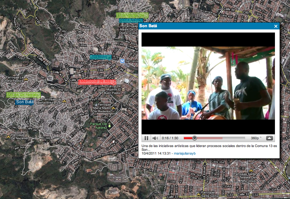
Comuna 13
http://www.youtube.com/watch?v=652V4OD9TY0 Muros armados En la Comuna 13 muchas historias muestran la realidad de la violencia y los crimenes de estado. Aqui visitamos la Escombrera, una montaña de escombros que por muchos años han descargado camiones con toneladas de piedra cemento y acero. Pero debajo de esta montaña llacen los cuermpos de cientos de personas que murieron en las diferentes intervenciones militares que hizo el estado para «recuperar» el control de ese territorio. Hoy en dia las fronteras militares siguen existiendo en la comuna 13.
http://www.youtube.com/watch?v=D8gs2cQWGuY El lenguaje de la gente El ritmo vertiginoso de la Comuna 13 ha generado movimientos juveniles que se resisten a la guerra. El grafiti es la memoria de los que están y los que se fueron así como el hip hop, la voz furiosa que se alza contra el poder de las armas. Esta generación esta indignada de su pasado y de la realidad que les toca vivir. Por esto, crea contra respuestas a la violencia injustificada del sector, entonces alzan la voz y empuñan sus aerosoles.
http://www.youtube.com/watch?v=UtvC6YPp2V8 Memoria de los ausentes En el Cementerio Parroquial de la América se han enterrado cientos de víctimas y victimarios de la historia de violencia que se ha dado en la Comuna 13. Las operaciones efectuadas por agentes del Estado en el año 2002: Mariscal, (mayo), Antorcha, (junio) y Orión, (octubre), fueron los catalizadores de un estado de miedo y tensión en la ciudad. Estas acciones militares dejaron en los ciudadanos un sesgo frente a la Comuna 13 a la que se juzga como una zona netamente violenta, lo que ha generado un desconocimiento de las iniciativas de desarrollo social, a través del arte, que se proponen desde los barrios que la conforman.
http://www.youtube.com/watch?v=QZvAgw6eiwo Zona neutra La historia de Luz Amparo es sencilla. se niega a pertenecer a algún actor del conflicto. esta posición la ha convertido en una líder comunitaria creadora de un espacio para los que son realmente ajenos a la guerra: los niños, los adultos mayores y los discapacitados. al igual que luz muchas personas se niegan a dejar la comuna 13, un resultado del arraigo que los obliga a defender su hogar, su territorio, su casa.
Participantes: María Juliana Yepes Burgos, Camilo Delgado Agudelo, Catherine Vieira, Carlos Mario Sánchez Pizarro, Helmuth Montoya Perez, Ana Cristina Villegas Calderón, Maria Isabel Velez Osorio, Alexander rodriguez, Lorena Marín, Oscar, Lady Johanna Quiroz, Andres Jimenez, Ivan Henao Velez, Manuela Saldarriaga, Aura Violeta Guevara, Angélica Díaz Forero, Alonso Gutierrez Mesa, Margarita Tovar, Carlos Andres Cano, Andres Felipe Castano, Miguel Angel Ramirez Benitez, Jorge William Agudelo Muñeton, Alí AM, Miguel Platohedro, Camilo Cantor, Alejandro Araque, Andres Meléndez, Pablo de Soto (completar).
Agradecimientos a Alejo Duque, Aniara Rodado, Marlin del Centro Cultural Moravia, a Falko, Romano y todo el parche de Moravia; y a Jehico y la Escuela de Élite, Son Batá, kinesica y todos los parçes de la Comuna 13.
http://www.youtube.com/watch?v=JnY_Ek9J33Y
Taller de videocartografía metropolitana, Medellín
“Los suburbios de las ciudades del tercer mundo son el nuevo escenario geopolítico decisivo” Mike Davis (Planet of Slums)
“Sea arte, sea deporte, sea de la manera que sea, queremos seguir arrebatando jóvenes a la violencia. Medellín no está lleno de sicarios, esto está lleno de talento urbano.” Falco (artista hip hop, Comuna de Moravia)
El taller de videocartografia metropolitana tuvo lugar en el contexto del encuentro LabSurlab en la ciudad de Medellin. LabSurlab fue un encuentro de la red de iniciativas independientes que conforman: hacklabs, hackerspaces, medialabs y todo tipo de laboratorios y colectivos biopolíticos operando desde y hacia territorios del Sur [de America] buscando desde la experimentación y creacion lograr sus propios espacios de acción y representación. En palabras de los organizadores: «Uno sobre otro para decantar así los vectores y posibles estrategias culturales de la sociedad red. ¿Por qué? la razón es bien simple, Medellín vive una vertiginosa transformación, existe una gran apuesta hacia lo tecnológico; la cual queremos, debemos, es nuestro interés repensar a partir de la componente experimental, artística y social de los medios.»
La última semana de julio de 2009 llevamos a cabo en Gijón un taller para niños sobre Open Street Map, el mapa libre del mundo que, al igual que la Wikipedia, está creado y actualizado por usuarios voluntarios.
Con el título Mapping Party: La aventura de los mapas, el taller se desarrolló durante el campamento de verano de LABoral Centro de Arte y Creación Industrial y participaron 20 niños de entre 6 y 9 años. El objetivo del taller era transmitir nociones básicas sobre el arte actual de la cartografía con medios digitales, y llevar a cabo un ejercicio práctico de «mapeo» de la zona de reciente transformación urbanística alrededor de la Ciudad de la Cultura de Gijóndonde transcurriría el taller.
El taller lo habíamos concebido inicialmente para preadolescentes y nos preocupaba que su contenido fuera demasiado abstracto o geek para niños de 6 y 7 años -por ejemplo, las representaciones en alzado y planta-. En contrapartida sospechábamos que los peques estaban familiarizados con la tecnología degeolocalización presente en muchos juegos y contenidos audiovisuales que consumen cada día, con lo que un acercamiento crítico a su uso, bondades y aspectos oscuros sería en cualquier caso interesante para ellos/as. Por requerimientos externos el taller tenía que ser muy comprimido -tres sesiones de 1h en días consecutivos-, con lo que teníamos que elegir muy bien que contenidos priorizar.
Día 1: Mapas y responsabilidad social
Del mapa en papel al digital
Comenzamos el taller en un aula de LABoral analizando comparativamente una fotografía aérea –la de la ciudad de Gijón– y la representación de esta misma porción de territorio en Open Street Map. ¿Qué diferencias hay entre las dos? ¿Qué son los mapas? ¿Cómo se «dibujan»? ¿Qué herramientas se emplean para ello? A la pregunta de como y desde donde se hacen las fotos que se utilizan para hacer los mapas los niños respondieron en una rápida secuencia: desde un helicóptero, desde un avión, desde el cielo, desde un satélite… En la siguiente explicación queríamos que se percataran de la escala y de la capa del espacio donde operan los satélites artificiales. Para ello, como si de una secuencia de la película de los Eames «Potencia de 10» se tratara, hicimos un alejamiento con Google Earth desde la visión aérea del edificio donde nos encontrábamos, zooming out progresivamente a la visión de la Tierra desde el espacio. Con la aplicación Celestia les mostramos cuales, de entre los cientos de satélites que hay, se emplean para revelar nuestras coordenadas geográficas. Son los satélites del sistema de posicionamiento global, 32 en total, que orbitan a 20.200 kilómetros de altura sincronizados para que seis de ellos sean visibles desde cualquier punto de la tierra. Les mostramos el tamaño real de un satélite en relación a una persona. A continuación explicamos como funcionan los dispositivos portátiles que se comunican con estos satélites. Les enseñamos en que consiste la triangulacióny los datos que proporciona el GPS (latitud y longitud, altura, velocidad, orientación), y el uso que le da la comunidad de «mapeadores»: moviéndose y registrando su huella o «traza» que luego se carga en el ordenador y sobre la que se dibuja una carretera o calle sobre el mapa. Entonces fue cuando les empezamos a introducir en el proyecto Open Street Map, un fenómeno colectivo realizado por miles de personas en todo el mundo para crear un mapa callejero de toda la superficie terrestre posible. Hicimos especial incapié en su espíritu colaborativo y de responsabilidad individual, así como también en la disponibilidad abierta y libre a través de la Red de sus mapas y datos en bruto. Para explicarles de una manera visual los resultados del trabajo de estos voluntarios les mostramos el video A year of edits, una animación de los progresos del proyecto durante el año 2008.
Descripción de la actividad
Generalmente las actividades didácticas de GPS con niños consisten en juegos del tipo «la búsqueda del tesoro» conocidos como geocaching, o de dibujo con gps. En nuestro caso, debido al cariz del proyecto de investigación que veníamos desarrollando -sobre la producción social de conocimiento sobre cartografía en la esfera digital-, planteamos directamente el ejercicio sobre la plataforma OSM y el estado actual del mapa de Gijón. Cuando estábamos buscando la zona donde llevar a cabo el trabajo de campo, nos encontramos con que el mapa de los alrededores de la Ciudad de la Cultura estaba desactualizado: no aparecía la nueva vía de acceso por el oeste, continuación de la Avenida Albert Einstein. Les mostramos a los niños la foto y el mapa de esa zona en Open Street Map, y en un ejercicio de responsabilidad ciudadana les propusimos trazar las calles que faltan y actualizar el mapa. Para ello el plan era salir caminando desde LABoral Centro de Arte y registrar nuestro recorrido con los dispositivos GPS, y la información geográfica recogida la volcaríamos directamente a OSM para ser utilizada libremente por cualquier persona. Los alumnos del taller podrían convertirse en los editores más jóvenes de Open Street Map de los que tenemos noticias. Descargar la ficha de la actividad
Día 2: Trabajo de campo
Comenzamos el día organizándonos en cuatro equipos, uno por cada dispositivo GPS con los que contábamos: tres teléfonos inteligentes con sistema operativo Android (dos de ellos prestados por un artista y programador de Oviedo) y un Garmin eTrex Legend (envíado desde Burgos por un compañero de OSM vía la lista de correo del proyecto). En los teléfonos instalamos la aplicación de dominio público gps logger que permite grabar las trazas en .GPX, formato de intercambio de datos GPS (el formato ligero de datos XML para intercambio entre aplicaciones y servicios web de Internet que emplea OSM). Se trataba no sólo de caminar la calle no representada en el mapa y registrar su huella, sino también sus características: el ancho de la vía, el número de carriles, las glorietas: OSM es básicamente un callejero. Para ello cada equipo de cuatro-cinco niños llevaría una camara de fotos, dos cuadernos de notas y lápices. Marina, una compañera de Barcelona que venía de hacer un taller sobre cartografía con niños en Campo de Caso -en los valles montañosos de Asturias-, nos ayudaría con la documentación. Ya saliendo del edificio los niños se iban fijando en que la pantalla del gps se empezaba a iluminar: conectando 4, 5, 6, 7, 8, 9 satélites. Durante el paseo, instamos a los grupos a anotar cualquier dato que consideraran importante -latitud, longitud, dirección, altura- así como a realizar fotografías de los nombres de las calles, tipos de pavimento, alrededores, etcetera. Esto devino en un debate interesante sobre qué datos son importantes y cuales no a la hora de representar la realidad en un mapa callejero. Por falta de tiempo no se completó la totalidad de la via, que fue recorrida por nosotros más tarde en bicicleta para completar la traza. Al llegar de nuevo al aula, se les dejó tiempo para que pusieran sus datos en común y repasaran mentalmente lo que habian hecho, asi como para introducir la agenda para el tercer día.
Día 3: Devenir cartógrafo/a
Comenzamos la última sesión del taller enseñando el funcionamiento JOSM, el editor de OSM, un software muy robusto pero sin un diseño especialmente adaptado para niños. Nos descargamos los datos geográficos de la zona correspondiente de Gijón y abrimos en distinto color las trazas de los cuatro equipos. Algunas tenían varios tramos separados ya que apagaron y encendieron el GPS en varios momentos durante el recorrido. Ahí descubrimos una vez más que es con los errores como se aprende y cuando el conocimiento se fija: con un trazado continuo no hubiera quedado tan claro a los chavales el funcionamiento y la precisión de la tecnología. En otras partes del recorrido donde la traza zigzagueaba hacia adelante y hacia atrás concluimos que fueron los momentos donde ¡una avispa se acercó a inspeccionar al grupo y lo hizo retroceder unos metros! El mapa con las calles añadidas ya había sido editado previamente por nosotros el día anterior y renderizado con OSMarender, la herramienta para generar imágenes vectoriales con los datos de OSM. Con la aplicación walking-papers lo habíamos preparado para impresión e imprimido una copia en A4 para cada niño. Les contamos a los chavales como en Haiti, después del terremoto, voluntarios de Open Street Map con la misma metodología que estábamos aprendiendo en el taller habían trazado desde cero los mapas que se estaban utilizando para organizar la ayuda humanitaria. Quisimos acabar el taller con un debate final sobre la tecnología y contra el tecnodeterminismo, ya que no queríamos que se fueran a casa con la idea que la geolocalización es benigna por si misma, en cualquier contexto o circunstancias. ¿Sobrevivirá el juego del escondite a la propagación de los chips gps y Rfidpor doquier? ¿Es bueno estar permanentemente «trackeados» por los satélites? Una de las respuestas de los niños a esta segunda pregunta -«no, porque nos pueden matar»- despertó la alarma de la monitora. Sin embargo, el niño que la hizo no iba tan desencaminado si recordamos el asesinato del líder checheno Dudajev en 1996. Un momento divertido se produjo cuando los niños preguntaron que país había lanzado el primer satélite artificial: los nombres del Sputnik y la Unión Soviética les resultaron totalmente desconocidos, pero no así la perra Laika.
Evaluación
La valoración del taller ha sido muy positiva. Pensamos que los objetivos iniciales de introducción a la cartografía digital y aproximación crítica a las tecnologías de geolocalización se han cumplido satisfactoriamente. Al igual que pasa con el software libre, Open Street Map es muy útil en términos educativos. Nos hemos quedado gratamente sorprendidos por el feedback y la capacidad de aprendizaje de nuestros jóvenes cartógrafos, así como la muy buena dinámica de grupo que había entre ellxs. Si bien OSM es un proyecto con una cierta barrera de género -hay muy pocas chicas participando-, en el taller no observamos ninguna diferencia en el interés mostrado en la actividad por niños y niñas, y fueron algunas de ellas las que nos pidieron que la actividad se repitiera el año que viene. Por nuestra parte también nos quedamos con ganas de repetir, quizás en algunas de las zonas de Asturias aun no trazadas en Open Street Map, o en otras vías y caminos del mundo.
‹ Volver atrás
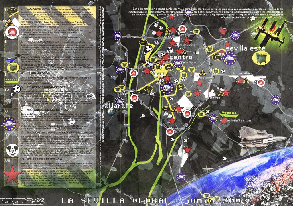
Seville Global Map
In Seville, on the eve of a large EU summit and concomitant protests in 2002, a collaborative mapping project was carried out with different community organizations to try to represent different effects of globalization on the city. The project drew on Zapatista frameworks of understanding, particularly those from the communiqués on “Seven Loose Pieces of the Global Jigsaw Puzzle” (Marcos 1997) and the “Fourth World War” (Marcos 2001). In this case, the map is part of a broader collective project of revisioning the city, a project that lasted much longer than the action itself.
This early mapping projects resembled street maps, although our goal was to chart the diversity of protest actions and events at one of the large anti-globalization protests. Individual groups could plot their different actions on a larger master copy and it could be used as an infopoint at a protest convergence centre or reprinted for handheld use. From these efforts at showing where protests were happening, later efforts focused on how to translate discussions of the effects of “globalization” on a city-wide scale.
‹ Volver atrás
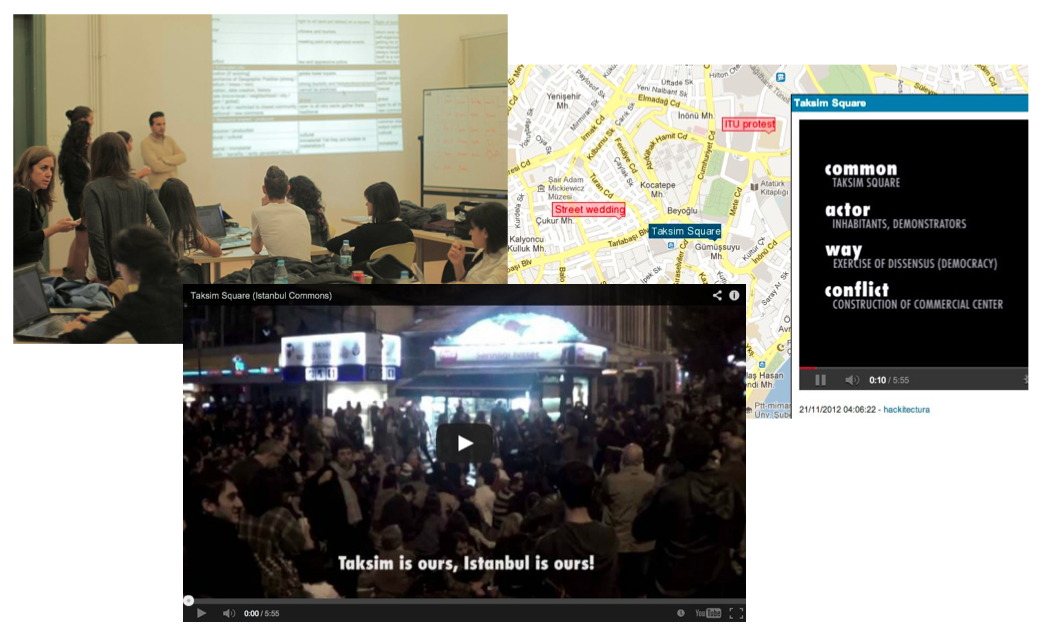
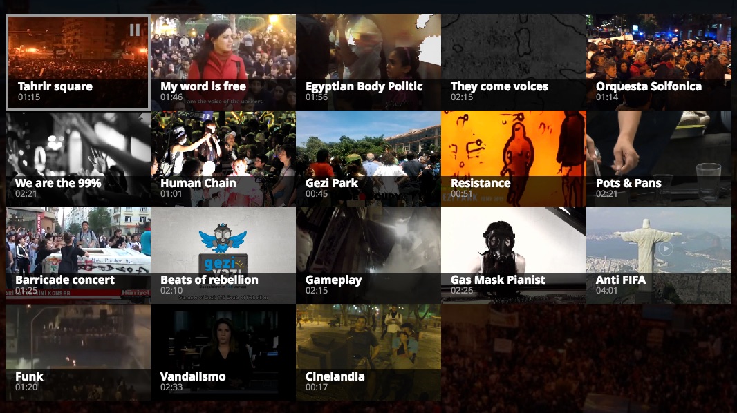
The Global Street
The Global Street is an online video-cartography linking the streets and squares the streets and squares across Tunis, Cairo, Madrid, New York, Tokyo, Istanbul, São Paulo, Belo Horizonte and Rio de Janeiro.
From the Arab revolutions to the 15M movement in Spain, from Occupy Wall Street in the USA to the Hydrangea revolt in Japan, from #direngezi in Turkey to the June Journeys in Brazil, music has played an essential role to sustain and in some ways synchronize protestors hearts, political agendas and imaginations.
The Global Street assembles a selection of affective songs and disruptive beats which were part of already historical atmospheres of democratic change: from the chanting crowds in Tahrir Square and Puerta del Sol to the Taksim Gezi Park barricade drums, from the Gospel band in Zuccotti Park to the Brazilian protest funk.
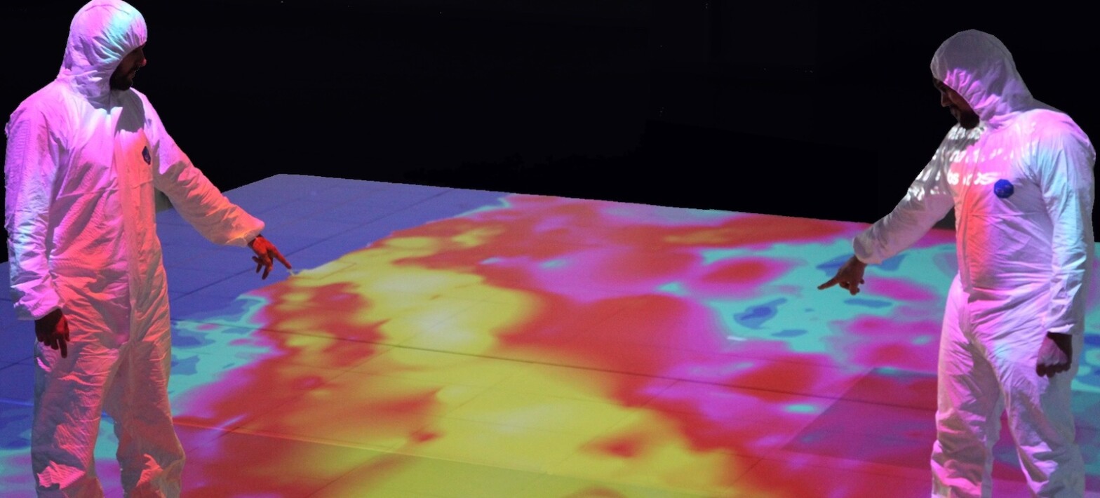
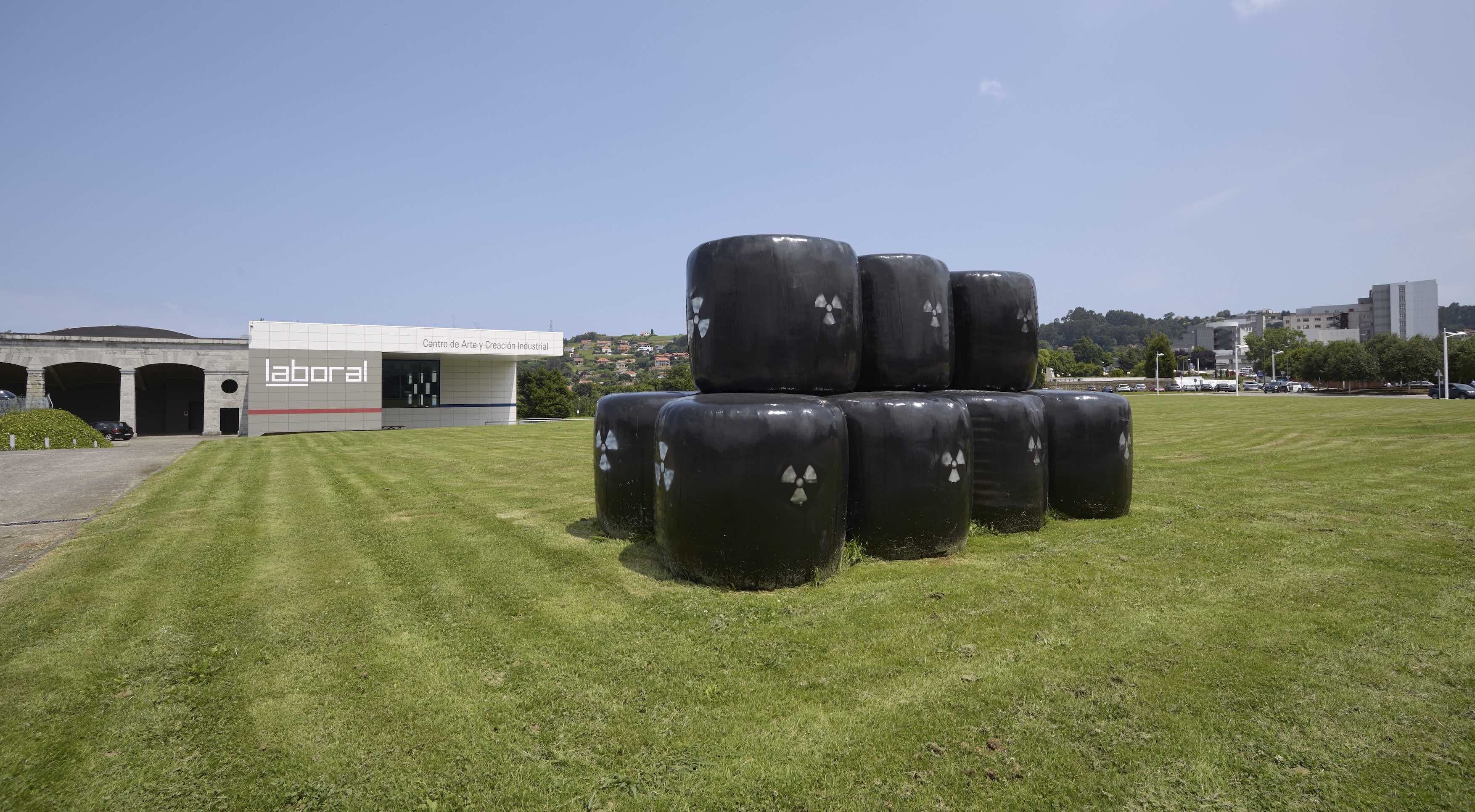
The Zone is a project by Román Torre and Pablo DeSoto. It is the winning project in the 6th DKV – Álvarez Margaride Production Scholarship, organised by LABoral Art Center in conjunction with the DKV insurance company, and it was produced during a residency at Plataforma 0, LABoral’s production centre. It was exhibited from June 20 to October 21, 2018
The Zone is an interactive installation that presents, in a didactic way, some elements of the exclusion zone of Fukushima in Japan. It reflects about the Anthropocene/Capitalocene landscapes of our damaged planet. It takes its name from a real physical space, the exclusion zone established as a consequence of the Fukushima nuclear disaster in Japan.
The exclusion zone is the evacuated area as a result of the maximum level nuclear accident unleashed when the earthquake and the tsunami forces of March 11, 2011, collided with The Fukushima Daiichi nuclear power plant. 160.000 people were forced to leave their homes and workplaces in a matter of minutes when the containment buildings which contain four reactors, began to explode one after another, spreading their invisible radioactive particles into the environment. The area declared uninhabitable for humans comprises a geographical area of 800 square kilometres around the destroyed nuclear power station.
The Zone is also a metaphor that constructs the mythology of the present, warning us against dreams of technological progress turned into nightmares. The project explores the possibilities of art & cartography displays in understanding contemporary environmental disasters.
The Zone. Photo by Marcos Morilla, courtesy of LABoral.The Zone. Photo by Marcos Morilla, courtesy of LABoral.The Zone. Photo by Marcos Morilla, courtesy of LABoral.
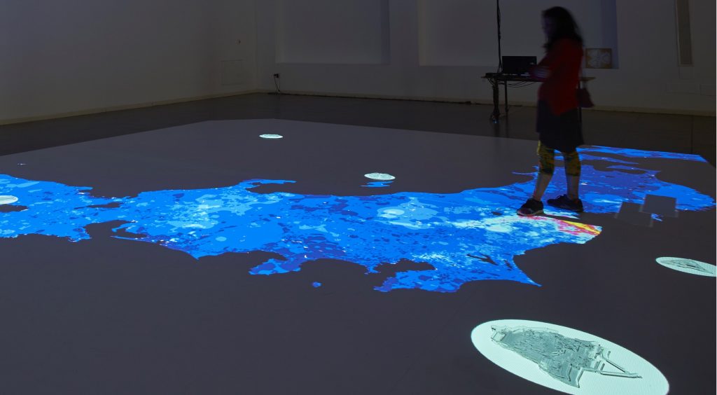
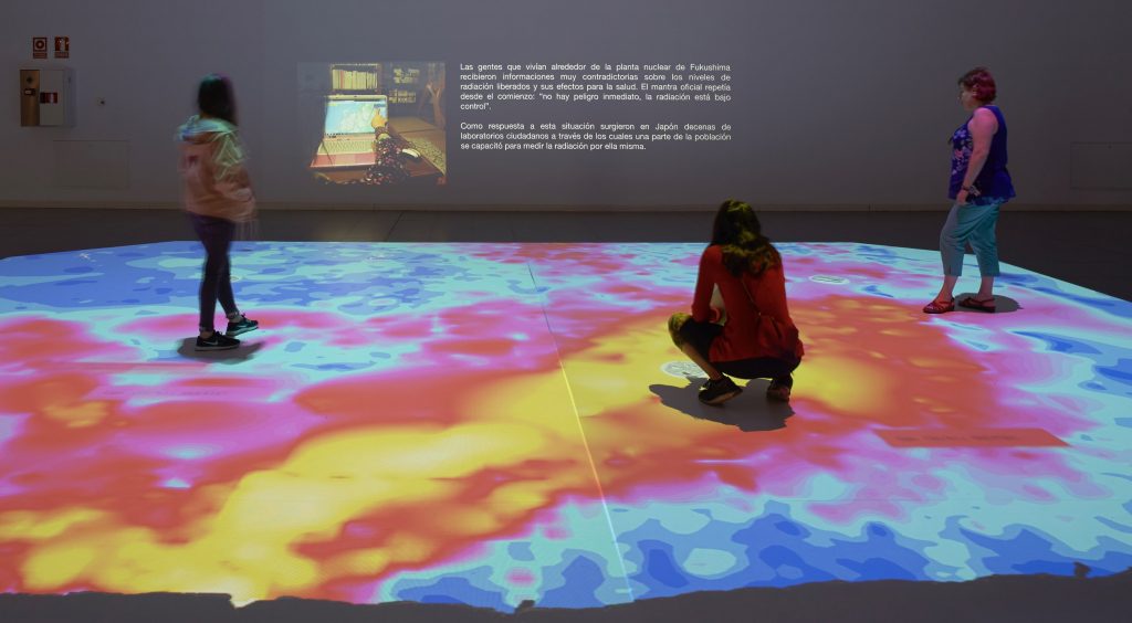
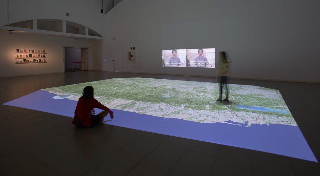
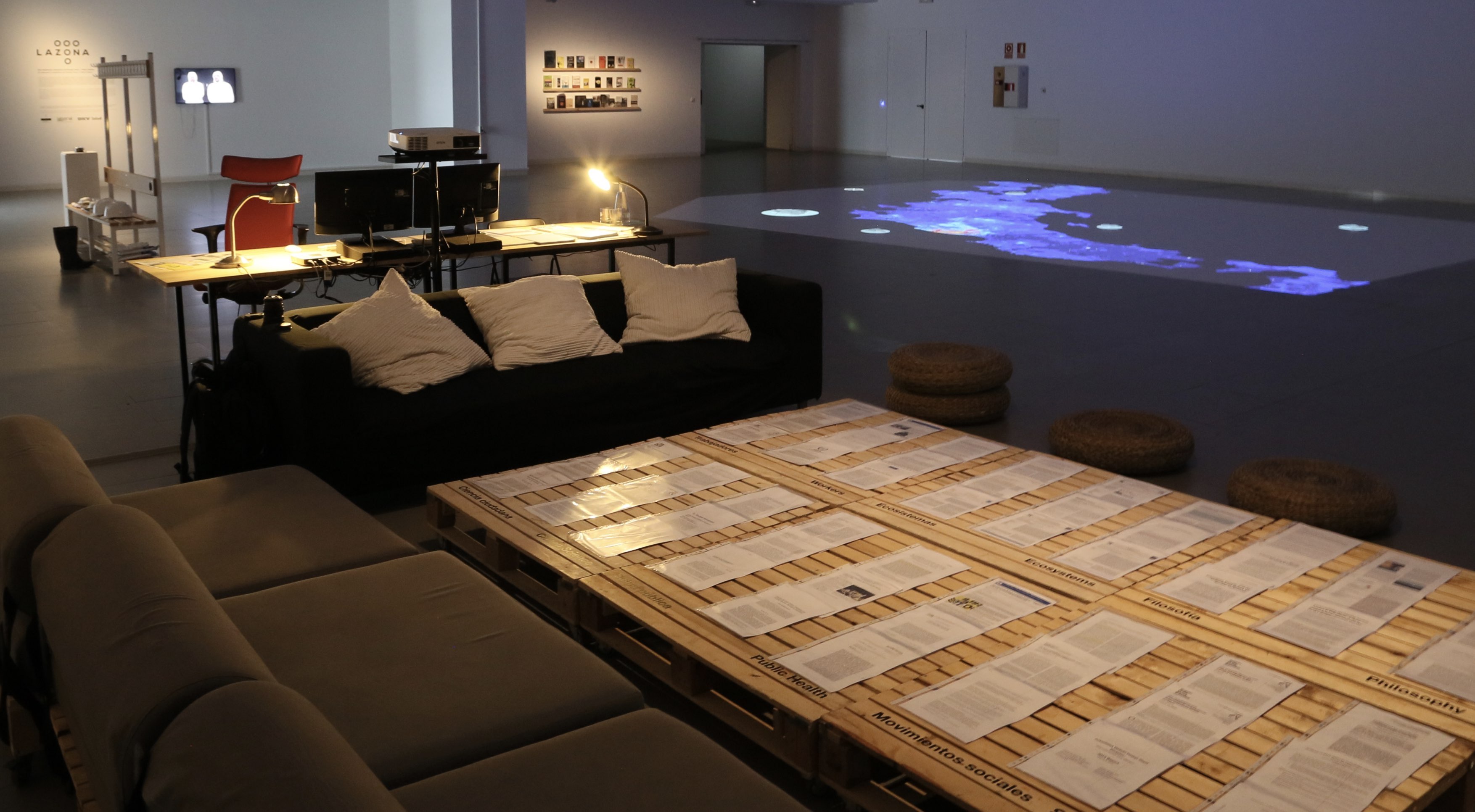
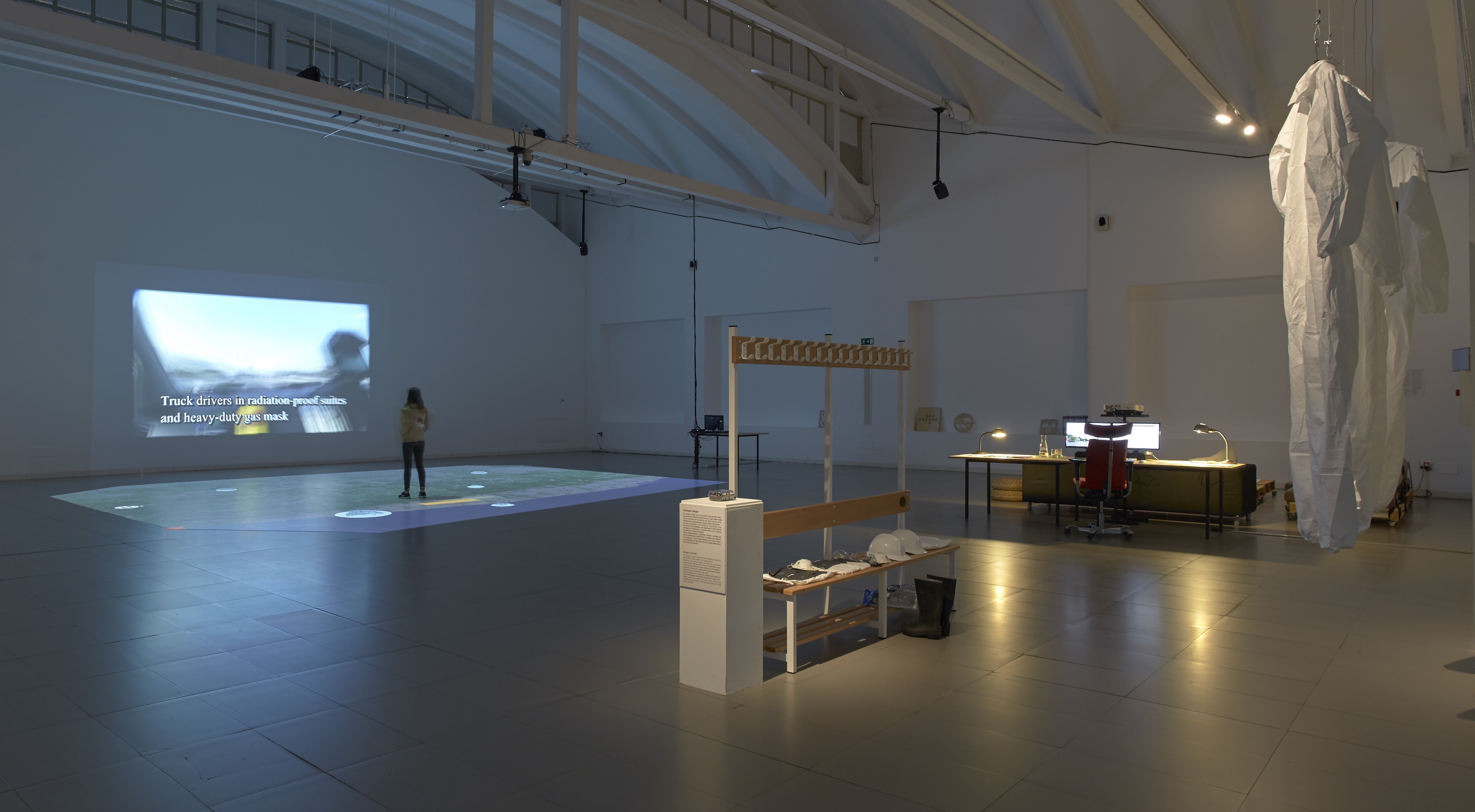
The project consists of four main parts: 1/ an outdoors installation, 2/ an interactive map, 3/ a workers area, 4/ a documentation area.
An outdoors installation occupy the public space at the entrance of LABoral Art Center. It consists of a deposit of radioactive bags evoking the storage facilities for contaminated soil from the nuclear crisis spread over all the ridges of Fukushima prefecture.
The main piece is an 80 square metres interactive map. The map is projected on the floor allowing the visitors to walk on the top of it. Five digitally fabricated objects on its surface, when approached by the visitor, activate a specific story. These stories include 1/ the earthquake and tsunami, 2/ the multiple nuclear reactor meltdowns, 3/ the evacuation of the population, 4/ the first journalist to get into the Exclusion Zone, and 5/ the citizen science as a response to the radiological disaster.
The workers’ area is a tribute to the thousands of workers, mostly subcontract ones, who enter Fukushima Daiichi Nuclear Power Plant everyday or work in the decontamination brigades. It includes a Geiger Counter developed by Safecast, a citizen science community established in Japan as a response to the nuclear disaster.
The documentation area includes books, reports, photos and academic papers on the Fukushima Daiichi nuclear disaster. It additionally includes resources from primary sources collected in Japan between November 2011 and February 2012. Selected Academic Papers are organised into six main categories: Social Movements, Citizen Science, Philosophy, Ecosystems, Activism, Workers and Public Health.

